Chapter Contents
- Chapter Glossary
- 12.1 Introduction
- 12.2 Identification and Tracking Ground Systems
- 12.3 Tracking Aids
- 12.4 Devices that Communicate Position and ID via Radio
- 12.5 Devices that Use Coded Light Signals
- 12.6 Future Efforts
- 12.7 Summary
- References
Chapter Glossary
| (18 SDS) | U.S. Space Force 18th Space Defense Squadron |
| (19 SDS) | U.S. Space Force 19th Space Defense Squadron |
| (CA) | Conjunction Assessment |
| (CARA) | NASA’s Conjunction Assessment Risk Analysis program |
| (CAESAR) | Conjunction Analysis and Evaluation Service, Alerts and Recommendations |
| (CCR) | Corner Cube Reflectors |
| (CNES) | Centre National d’Etudes Spatiales (French Space Agency) |
| (COTS) | Commercial-off-the-Shelf |
| (CUBIT) | CubeSat Identification Tag |
| (D/T/I) | Detection, Tracking and Identification |
| (EGTN) | ExoAnalytic Global Telescope Network |
| (ELROI) | Extremely Low Resource Optical Identifier |
| (EUSST) | European Union Space Surveillance and Tracking program |
| (FCC) | Federal Communications Commission |
| (GEO) | Geosynchronous Equatorial Orbit |
| (GNSS) | Global Navigation Satellite System |
| (GPS) | Global Positioning System |
| (GUI) | Graphical User Interface |
| (HEO) | Highly Elliptical Orbit |
| (HUSIR) | Haystack Ultrawideband Satellite Imaging Radar |
| (ILRS) | International Laser Ranging Service |
| (LEDs) | Light Emitting Diodes |
| (MEO) | Medium Earth Orbit |
| (NPR) | NASA Procedural Requirement |
| (NTE) | Nanosatellite Tracking Experiment |
| (NTIA) | National Telecommunications and Information Administration |
| (OCAP) | Orbital Conjunction Assessment Plan |
| (OD) | Orbital Determination |
| (OEM) | Orbit Ephemeris Message |
| (O/Os) | Owner/Operators |
| (OSAs) | Orbital Safety Analysts |
| (PNT) | Position, Navigation, and Timing |
| (RF) | Radio Frequency |
| (RFID) | Radio Frequency Identification |
| (SRI) | Stanford Research Institute |
| (SSA) | Space Situational Awareness |
| (SSN) | Space Surveillance Network |
| (SWaP) | Size, Weight, and Power |
| (TLE) | Two-Line Element |
| (TraCSS) | Traffic Coordination System for Space |
12.1 Introduction
In the past, most launches involved a single, large satellite launching on a dedicated launch vehicle. Small satellites as secondary payloads were sometimes “dropped off” along the way to the primary payload’s orbit or rode along to the final orbit with the primary payload. In either case, it typically was not that difficult for tracking radars to distinguish between primary and secondary payloads based on size and operational parameters.
Recently, however, multi-manifest or “rideshare” launches have become more common, and providers (1)(2)(3) are launching multiple CubeSats, or bundling CubeSats and other smaller payloads with larger payloads to fill up the excess capacity of almost any given launch vehicle. For technical and cost reasons, such launches generally deploy small satellites and CubeSats into very similar orbits over a short time window. “Batch” launches with a lack of separation between satellites can prevent effective tracking and create “CubeSat confusion” (4). When CubeSats are deployed close together in space and time, they can be difficult to distinguish from each other by tracking radars, making it difficult to determine which orbits correlate to which spacecraft, preventing a unique orbital state for each object from being added to the catalog of on-orbit objects (5)(6). Even when successful, these objects frequently remain unidentified for a lengthy period of time. It is not unusual for the process to take weeks to months to sort out which object is which, while some may never be positively identified at all. If the orbital states cannot be determined and the spacecraft cannot be added to the catalog of on-orbit objects, neighboring satellites may be unaware of close approaches, thereby hindering their ability to mitigate risks of collision. Furthermore, if identification is not resolved then conjunction warnings may not be sent to the responsible party or – even worse – they may be erroneously sent to an incorrect party if a mis-identification occurs.
Due to their standardized shape and size, CubeSats look very similar to one another, especially when they are in orbit hundreds of kilometers away. If there are unidentified objects from a launch, then the possible number of associations of object identifications (IDs) to tracked objects scales as n! (n-factorial, where n is the number of unidentified space objects from the launch). For example, if there are just two objects, say a payload and an upper stage, there are two ways in which you can associate the IDs with the tracked objects, and even that can be a challenge (7). However, if there are ten unidentified objects, there are 3,628,800 possible combinations; with 20 this rises to 2.4×10¹⁸ combinations. The magnitude of the problem becomes large very quickly. Annually, several multi-manifest deployments already deliver over 100+ objects per launch. As new launch vehicles come to market, this capacity is anticipated to increase to several hundred objects per launch, meaning that an already acute problem will only intensify.
Small satellites can improve their chances of being identified and tracked through good coordination with tracking agencies pre-launch, through community sharing of position/velocity, maneuvering, and covariance data in clearly defined, consistent, standardized formats (ex: Orbit Comprehensive Message (OCM)), and through careful selection of deployment direction and timing (8). Good spacecraft design choices can also improve the chances of small satellites surviving launch and early orbit (9), and can even make use of in-space commercial radio networks as a “back-up” method of communicating, should primary systems fail (10). However, despite improvements in both design and coordination, many small satellites still go unidentified. This has led to the introduction of tracking aids – independent systems that help owners and trackers identify small satellites and CubeSats, in some cases even if the satellite is malfunctioning.
Even if a small satellite is trackable (or rendered trackable through one of the enhancements discussed below), it is important that this position information be combined with satellite planned maneuver information and packaged into a predicted ephemeris that can be sent regularly (at least daily) to a conjunction assessment (CA) screening authority. The only way that CA screenings can be meaningful is if a satellite’s future position is used by the screening authority in the screening process. Non-cooperative tracking, even if it is well and frequently performed, cannot anticipate satellite maneuvers, and this information is essential to a robust conjunction assessment system. Maneuverable satellites (which include satellites that employ non-propulsive trajectory modification methods, such as differential drag) must assemble and furnish durable predicted ephemerides to the screening authority, either through indigenous means (i.e., unaided tracking and their own flight dynamics system’s production of a predicted ephemeris) or via one of the position determination approaches to be described in order to ensure the operators are aware of close approaches with them. Non-maneuverable spacecraft need only ensure that they are trackable, although the CA best practices documents (12) all stress the importance of owner/operators (O/Os) taking responsibility for ensuring that screening authorities possess timely and accurate predicted position information for their spacecraft.
O/Os need not perform ephemeris generation themselves; there are several commercial companies that will perform this function on their behalf, and it is plausible that government systems will have a similar capability in the near future. O/Os can furnish a third-party provider with their on-board Global Navigation Satellite System (GNSS) data and their maneuver plans, enabling the provider to produce a predicted ephemeris with a realistic covariance regularly (i.e., at least daily in LEO, three times daily for orbits with perigees below 500 km) and furnish it to the appropriate screening authority. It is important that quality orbit determination be performed in such cases, which means both accurate predicted state estimates and, perhaps even more important for orbital safety, realistic covariance matrices accompanying each ephemeris point. Because satellite collision likelihood calculations require a statement of the state prediction uncertainty in order to compute the probability of collision, it is very important that realistic covariance estimates be produced and included with the ephemeris; this is not always a routine flight dynamics product, so it is necessary that ephemeris “vendors” be queried about their abilities to tune their organization development process to produce realistic covariances and their methodologies for verifying covariance realism. The NASA Conjunction Assessment Risk Analysis (CARA) repository, (search for “NASA CARA Analysis Tools”) contains covariance realism evaluation code and associated theoretical and technical documentation. Small missions or university research CubeSat endeavors are offered special rates by some firms for ephemeris generation, so such O/Os should ask about special pricing structures that may make ephemeris data quite affordable.
While the thrust of the above comments pertains to routine satellite identification and tracking once a satellite is firmly established in its final orbit and placed into the space catalogue, a particular problem occurs directly after satellite injection but before cataloguing—the collision avoidance “COLA Gap.” During large launch deployments, it is often difficult to reliably distinguish multiple spacecraft, and it can take days or even weeks for enough spacecraft separation and regular tracking to occur to allow durable cataloguing. Because only catalogued objects are accommodated by the conjunction assessment enterprise, spacecraft caught in the COLA Gap are not included, thus creating a collision danger both to other satellites and to themselves. Producing an ephemeris from on-board GNSS information or using one of the beacon or tracking aid devices enumerated below can allow a deployed satellite’s current position, and therefore predicted position ephemeris, to be assembled rapidly. This ephemeris can be forwarded as a special submission to the CA screening process, thus closing the COLA Gap.
Finally, it should be recognized that regular predicted orbit information is required until spacecraft demise, not just during active operations. Operators should consider this obligation when selecting a deployment orbit. If a satellite is not regularly trackable by non-cooperative sources such as the United States Space Force Delta 2, this problem must be addressed through other means, such as processing of on-board GNSS information to produce a predicted ephemeris. This mechanism needs to persist fully through spacecraft re-entry or placement in a disposal orbit. This requirement is one reason that independently powered GNSS beacons are an attractive solution for satellites that are not easily trackable and will not pursue active deorbit at the end of their main mission. GNSS beacons also offer more precision than traditional, non-cooperative sources which has advantages in congested regions of space. Tracking is also important for spacecraft in cislunar space, where non-cooperative tracking is limited and GNSS solutions may not be technically feasible.
The information described below is not intended to be exhaustive but provides an overview of current state-of-the-art technologies and their development status for a particular small spacecraft subsystem. It should be noted that Technology Readiness Level (TRL) designations may vary with changes specific to payload, mission requirements, reliability considerations, and/or the environment in which performance was demonstrated. Readers are highly encouraged to reach out to companies for further information regarding the performance and TRL of the described technology. NASA does not endorse any of the companies or technologies described. Finally, there is no intention of mentioning certain companies and omitting others based on their technologies or relationship with NASA.
12.2 Identification and Tracking Ground Systems
The United States Space Force Delta 2 is responsible for performing space surveillance and providing foundational Space Situational Awareness (SSA) for the US Department of Defense as well as for other agencies and space entities. Delta 2’s 18th Space Defense Squadron (18 SDS), located at Vandenburg Space Force Base in California, performs all catalog maintenance functions, including detection, tracking, and identification (D/T/I) of artificial objects in Earth orbit, and maintaining the space catalog which is publicly available on Space-Track.org. As part of their activities, they provide launch support, re-entry assessment, and other SSA functions. Orbital safety activities, such as conjunction assessment (which identifies close approaches between launch and other catalogued in-orbit objects) are provided by Delta 2’s 19th Space Defense Squadron (19 SDS) at the Naval Support Facility at Dahlgren, VA. Maintaining the catalog is achieved via the US Space Surveillance Network (SSN), which is formed by a suite of sensors around the world (15). 18 SDS is currently tracking more than 50,000 objects in Earth orbit and can provide data for pieces as small as 10 cm in characteristic length.They issue two-line elements (TLEs) that are updated on a regular basis and can be used to compute predicted orbit positions for spacecraft communications acquisition and other purposes. They also produce precision vectors with covariance that can be used to perform conjunction analyses. TLEs are not accurate enough to be used for conjunction assessment, and do not include covariances that are needed to compute a probability of collision.
The US Space Force next generation SSA sensor, known as the Space Fence, was declared operational in March 2020 and can track objects below the previous 10 cm limit. It is located on Kwajalein Atoll, in the Republic of the Marshall Islands, and consists of a S-band radar system to track objects primarily in low-Earth orbit, although it can track objects in medium-Earth orbit (MEO) and geostationary equatorial orbit (GEO) as well. The 20th Space Surveillance Squadron based in Huntsville, Alabama, manages the Space Fence and provides data to 18 SDS to augment the space catalogue (16). Another important sensor in the SSN is the Haystack Ultrawideband Satellite Imaging Radar (HUSIR), which is the highest-resolution, long-range sensor in the world. HUSIR simultaneously generates X- and W-band images that can provide valuable information about the size, shape and orientation of Earth orbiting objects (17). These are just two examples of sensors that make up the SSN, many having specific unique capabilities that support the SSN’s various functions, including conjunction assessment.
The NASA CARA program acts as the intermediary between 18/19 SDS and NASA satellite missions. CARA gathers orbit ephemeris and covariance files from the NASA spacecraft operations teams and provides this data to NASA’s Orbital Safety Analysts (OSAs) at Vandenberg for screening and close approach prediction. CARA provides risk assessment of these predicted close approaches to NASA missions beyond the 19 SDS support provided to non-NASA users, including operations concept development, specialized probability of collision computation, high interest event notification, and conjunction geometry analysis, among other functions (14). The French Space Agency (CNES) created a conjunction risk assessment team called Conjunction Analysis and Evaluation Service, Alerts and Recommendations (CAESAR) that provides risk assessment services to their missions as part of the European Union Space Surveillance and Tracking (EUSST) program (18).
In 2023, NASA released Revision 1 to their best practices handbook entitled “Spacecraft Conjunction Assessment and Collision Avoidance Best Practices Handbook,” which is a great reference for satellite operators with respect to collision avoidance topics (12). NASA Procedural Requirements (NPR) 8079.1 codifies those best practices as requirements for NASA space flight programs, projects, and vehicles to protect the space environment and reduce the risk of collision (13).
Besides USSF Delta 2, several commercial entities are providing tracking capabilities that can be purchased by stakeholders. ExoAnalytic and Slingshot Aerospace each operate global telescope networks consisting of dozens of observatories and hundreds of telescopes tracking orbiting objects in GEO, highly elliptical orbit (HEO), and MEO. The Exoanalytic Global Telescope Network (EGTN) can collect angles and brightness measurements. They each maintain a proprietary catalog of satellites and space debris that are regularly tracked and cataloged (19).
LeoLabs is another commercial entity providing spacecraft tracking and support services. They use a group of distributed Earth-based, phased-array radars to make a commercial-off-the-shelf (COTS) satellite tracking service targeted to the specific requirements of SmallSat operators in low-Earth orbit. They currently have radar locations in New Zealand, Costa Rica, the Azores, Poker Flat, AK, Midland, TX, Arizona, Western Australia, and Argentina. There are currently seven functioning radar sites as of 2024, with plans for more radars strategically located around the world to track objects down to size levels approaching those tracked by the DoD. The predicted performance also includes a revisit time of over 10 observations per day for specific objects. Through their LeoTrack platform, they can use their radar data to perform precision tracking and curate orbit information products for satellites as small as 1U. Their system includes an open-source graphical user interface capable of displaying all the catalog in real time, as well as fundamental orbit information about each individual object. They also offer a commercial launch and early orbit service, with SpaceX as one of their historic customers (20).
Catalogs provided by these commercial entities are different from the one maintained by 18 SDS in accuracy and objects included. Spacecraft owner/operators should be aware of the differences before choosing to use a particular service for a particular purpose. For conjunction assessment purposes, having multiple differing solutions can be confusing. The Department of Commerce was charged in Space Policy Directive-3 with creating a space traffic coordination system that enables commercial capabilities for conjunction assessment. In the future they may offer a conjunction assessment service that merges data from multiple sources in one solution as they work to transition the service currently provided by 19 SDS. Initial capability of the Traffic Coordination System for Space (TraCSS) is planned for 2026. Lessons learned from NASA’s Starling (launched July 2023) and Starlink constellations are being fed into the design of TraCSS.
NASA’s Starling 1.5 mission extension, using the four-CubeSat Starling swarm of spacecraft, was built on the Starling primary mission demonstration of autonomous maneuver planning and execution. Partnering with SpaceX and their Starlink constellation, Starling 1.5 demonstrated an advanced space traffic coordination solution for co-located groups of autonomous spacecraft from different owner/operators. The onboard autonomous maneuvering software for the original Starling mission, consisting of Emergent Space Technologies (acquired by York Space Systems) Navigator and Autopilot products, can perform probability of collision calculations and propose risk mitigation maneuvers for conjunctions with co-located vehicles. A space traffic coordination hub on the ground will be able to receive maneuver responsibility claims from an operator, indicating that they intend to maneuver to reduce the conjunction risk, receive and screen proposed new trajectories in near-real-time, and provide operators conjunction data messages with screening results. This will enable highly automated operations, including conjunction risk assessment and mitigation between satellite owner/operators.
12.3 Tracking Aids
For spacecraft that cannot be routinely tracked by the SSN, it is important to ensure trackability by another means to enable other owner/operators to know where your spacecraft is to prevent debris-producing collisions. This is especially important for SmallSats that have orbital lifetimes that exceed operational lifetimes, as the risk to orbital neighbors remains after tracking activities have stopped. For NASA spacecraft, trackability until demise is required in NPR 8079.1 and assessed as part of the required Orbital Conjunction Assessment Plan (OCAP) written during design.
Tracking aids come in several categories, each with benefits and drawbacks (21). Table 12-1 summarizes the broad categories available, with representative examples discussed below. Size, weight, and cost vary for each of the examples, but all can be considered compatible with a CubeSat mission; see the references for detailed information on size, weight, and power (SWaP) and cost, all of which become more favorable each year with technology improvements and economies of scale. Once the augmented tracking data is collected, ephemeris data is made available to CARA/19 SDS for screening.
Several commercial companies offer services that will process the data produced by tracking aids and produce predicted orbit ephemeris data that can be used to perform conjunction assessment. These include SpaceNav, COMSPOC, and Kayhan Space, with Kayhan Space focusing specifically on small spacecraft support.
| Table 12-1: Types of Tracking Aids | |||
|---|---|---|---|
| Technology Scheme | Description and Reference Mission | TRL | Citation |
| CubeSat position and ID via radio | A position, navigation, and timing (PNT) receiver is attached to a CubeSat, along with a radio to transmit the information via a LEO communications provider (or directly to the ground); example: BlackBox, Blinker. | 7-9 | (22) (23) |
| Coded light signals from light source on exterior of CubeSat | Exterior-mounted LEDs with large-aperture telescopes to receive the signal or diffused LED lasers with ground-based photon-counting cameras. | 6-7 | (24) (25) |
| Radio Frequency interrogation of an exterior Van Atta array | For example, exterior mounted radio frequency identification (RFID) tag & commensurate radar. | 7-9 | (26) |
| Laser interrogated corner cube reflectors (CCR) | One or several small CCRs can be attached to CubeSat exterior; ground-based laser and receiver telescope needed to distinguish number of CCRs. | 7-9 | (27) |
| Passive augmentations to visibility | Use of high-albedo paint or tape, improving overall conductance of the exterior of the satellite or other methods to increase visibility. | 7-9 | |
| Orbital Whereabout Locator (OWL) | A tuna can mounted plug and play device equipped with a battery that helps identify and keep track of a satellite with a GNSS based tracker, monitors key parameters of a satellite and downloads data using an omnidirectional antenna in any orientation. | 7-9 | |
12.4 Devices that Communicate Position and ID via Radio
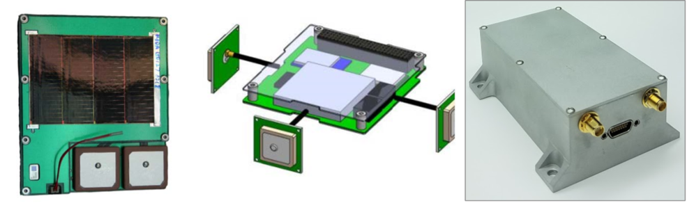
The most comprehensive (but also potentially the most complex and SWaP-intensive) option involves equipping a small satellite with an independent positioning, navigation, and timing (PNT) receiver and a separate radio capable of transmitting data to an independent communications provider. An example technology is the Black Box system by NearSpace Launch, Inc. that comes in several form factors for mounting internally or externally to a small satellite or CubeSat. The patch antenna shown in the first image is approximately 10 x 8 cm and can weigh as little as 22 grams; larger systems such as the one shown in the third image of Figure 12.1 have flown and are considered TRL 9. Another example often used for CubeSats is the NovAtel OEM7700. JAXA offers a strap-on tracking device called mini-Mt. Fuji; they can provide sensor tracking, or operators can track it themselves. These systems combine a low-power GPS receiver with a low-power radio capable of communicating with a low-Earth orbit communication provider (in the case of Black Box, the Iridium network), and operate independently from the spacecraft’s regular command and telemetry links. Externally mounted versions often include solar cells for independent power generation. A Black Box system is currently flying on Spaceflight Sherpa-FX orbital transfer vehicle, launched on January 24, 2021, and returned GPS fixes to the developer which were analyzed and presented at the October 2021 and October 2022 International Astronautical Congress (28). As a further service, NearSpace Launch can generate a low- or high-precision ephemeris for one’s satellite and furnish this to the O/O, who can then submit it to a CA screening authority.
The advantages to such a system are that it provides complete data on a satellite’s position and requires no specialized ground equipment (other than the equipment used by the communications provider). Some such systems are independently powered and can provide data even if the host satellite never powers up, though others are dependent on spacecraft power to function. These systems are the most complex of the tracking aids described, however, and despite their relatively small size, are still the most SWaP-intensive of the options examined. Systems that rely on power from the host vehicle are also useless if the host vehicle suffers a power anomaly or failure. Having an additional onboard radio that communicates with other space assets necessitates additional oversight by the Federal Communications Commission (FCC) (or National Telecommunications and Information Administration (NTIA) for US Government missions licensing and coordination).
In choosing such systems, it is important to choose one that is spac- rated, otherwise pre-launch testing must be performed via simulation. The system should also provide fast convergence after launch to allow rapid computation of an orbit determination solution to provide to 18/19 SDS for conjunction assessment screening as soon as possible after separation; this allows solution of the “COLA Gap” problem, namely providing orbital safety information and capabilities between payload injection and the time of the satellite’s cataloging, which could be as long as several weeks. Other available features, like multi-frequency, multi-GNSS, and availability of pseudoranges are nice-to-have, but the benefit for conjunction assessment is marginal vs. just having a receiver. If flying a GPS system, it is important to ensure that the GPS data be available in the download stream and not just internally available to the spacecraft computer for onboard use.
Overall, when selecting such a system, the following considerations apply:
- Independent power of the device to ensure that it continues to function in the presence of internal spacecraft faults and be able to issue position information all the way until spacecraft demise;
- An ephemeris generation capability, either as a service from the device manufacturer, an indigenous capability of the O/O, or a service provided by a third-party provider. These ephemerides need to be submitted at least daily to the CA screening authority;
- The inclusion of planned satellite maneuvers in the predicted ephemeris to be furnished; and
- The existence of a ground network and communications path to allow the regular receipt of the broadcast data to achieve the requirements stated above.
It is also important to note that this approach can truly operate without a priori orbit state knowledge. That is to say, it does not require prior knowledge of an object’s location in space to provide a tip or cue for initial or subsequent interrogation. Such data is often necessary with other approaches described below (to varying degrees) but is not required for this family of devices, because the radios are either omnidirectional or the receiver network is sufficiently proliferated that broadcasts can be received from any orbit without such prior knowledge.
12.5 Devices that use Coded Light Signals
Identification systems and devices that make use of light emitting diodes (LEDs) and coded light signals have the advantage of being relatively simple and capable of uniquely identifying satellites. However, all systems flown to date have required power from the host satellite, leading to issues with detection (29) if the host satellite fails to power up. Current implementations are also relatively large, though future systems are expected to be much smaller and may include independent power. Devices such as the Extremely Low Resource Optical Identifier (ELROI) beacon (Figure 12.2), under development by Los Alamos National Lab (29), use exterior-mounted LEDs or diode lasers that blink in a prescribed sequence to uniquely identify satellites. The ELROI system is designed to be independently powered by a small solar cell and battery and is packaged into a system as small as a Scrabble tile, though only larger systems – with power provided by the host satellite – have flown.
The emitters on such devices can be regular LEDs or diffused diode lasers but require specialized ground equipment – either a large-aperture telescope or a photon-counting camera – to track and identify the object as it passes overhead. Figure 12.2 (right) shows how the ELROI system works: a photon-counting camera attached to a telescope tracks the signal from a diode laser and decodes the ID of the host satellite from the on/off pattern of flashes. ELROI successfully demonstrated definitive identification on two CubeSats, LaCE-1 and R5-S4 in 2024 and 2025.
LED-based systems require relatively clear night-time skies for identification and dedicated ground equipment (telescope and sensor). The light sources are too faint to allow blind searching of the sky for the satellite; orbital information from a SSA provider is also required to find and track the CubeSat, although the process of tracking the satellite via an optical telescope allows the orbital ephemeris to be updated. Therefore, this tracking enhancement alone cannot be used to identify and catalogue the spacecraft. Issues with attitude control on the host satellite can also complicate the identification process. In addition, using LEDs or other light sources on a satellite while in Earth’s shadow should be done carefully to minimize interference with astronomical observations. The SatCon1 report (37) on page 6 lists several recommendations to be followed: 1) assure the light source is fainter than apparent magnitude of V ~7 (and the fainter the better), and 2) provide advance notice of any illumination times, including accurate orbital elements.
12.5.1 Van Atta Arrays and RF Interrogation Receivers
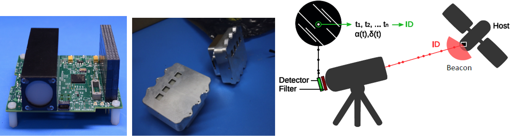
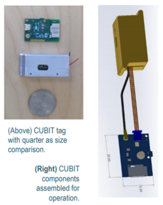
Another method for increasing the ability to track and identify small satellites involves devices that respond when interrogated by a radio frequency (RF) signal of appropriate wavelength. One such system, the CubeSat Identification Tag (CUBIT) shown in Figure 12.4, is like the RFID devices used in proximity badges (26). Built by SRI International and partnered with NASA Ames, CUBIT responds with a short burst of information when interrogated by a radio signal of the correct frequency. CUBIT is relatively small and designed to be independent of host vehicle power. The implementations that have flown contain a small battery suitable for 30 days of in-orbit life, which covers the most critical early orbit identification period. It could therefore be coupled with a coded light emitter to overcome the inability of that system to allow object identification. The device is separated into an internally mounted electronics unit attached to an exterior antenna to minimize the exterior footprint of the unit. Two units have flown and were successfully demonstrated in space onboard TechEdSat-6 in 2017 and TechEdSat-7 in 2020. A relatively large ground architecture (in CUBIT’s case, a 30 m antenna and an array of antennas) is required to interrogate the system and successfully acquire the low-power response. CUBIT is patent-pending, and SRI has reached commercialization agreements with potential vendors. Future research will continue with a recently awarded AFWERX Phase 1 study.
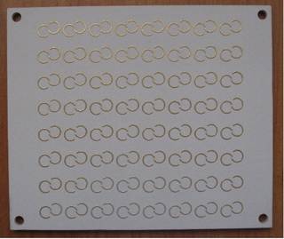
Another example of an RF-interrogated device is a Van Atta array, a passive device that re-radiates RF energy back to its source (30). One such device, the Nanosatellite Tracking Experiment (NTE) consists of a 64-element Van Atta array of tiny, paired antennas tuned to a Ku-band RF frequency, as shown in Figure 12.5 (31). When interrogated at the proper frequency range, the incident RF field received by each antenna is fed to a corresponding antenna via a passive transmission line, where it is re-radiated. This significantly increases the radar cross-section of the object, allowing it to be more easily tracked. Unique identification is difficult, however, and requires specialized ground stations that tend to be expensive to operate. A satellite carrying a Van Atta array device will be distinguishable from one not carrying such a device, or from one carrying a device tuned to a different frequency band, but two satellites carrying identical Van Atta array will return the same signature. The RF interrogation also requires a ground source of the appropriate frequency. However, Van Atta array devices are entirely passive and extremely low SWaP, making them easy to include on small satellites and CubeSats. NTE devices have flown in space but results from those flight experiments have not yet been published.
No capability currently exists at the SSN to process Van Atta array data, so it would be incumbent on the spacecraft operator to produce its own orbit determination solution from the data to provide an ephemeris to 18/19 SDS for CA screening.
12.5.2 Laser-Interrogated Corner Cube Reflectors
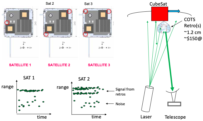
Corner cube reflectors (CCRs), long used in the space industry, are special mirrors designed to reflect laser light back in the direction from which it originated. They require no internal energy source. When illuminated by a laser, they provide a return signal that can be detected on the ground by a fast camera, as seen in Figure 12.6. Putting a different number of CCRs on a set of CubeSats allows the ground station to differentiate between the CubeSats (i.e., a CubeSat with one CCR will produce a different return signal from another with two CCRs or three CCRs, etc.). One can use a laser and telescope system like those employed by the International Laser Ranging Service (ILRS) (32), which are high-TRL systems that have been operating for decades. Precise a priori orbital information is required to lase the CubeSat and receive a return signal, and the number of satellites that can be uniquely identified is limited by the number of corner cube reflectors that can be attached.
12.5.3 Passive Increase in Albedo
The simplest method of increasing satellite trackability involves using high-albedo paint, special tape, or other simple methods to increase the optical or radar visibility of a small satellite, allowing it to be more easily detected by ground-based systems (33). White-colored thermal paint has been used for years to increase the ability of satellites to reject heat, which also improves their visibility and trackability. Additionally, CubeSats often deploy a mission-specific configuration of wire antennas and/or cylindrical boom structures which can serve as unique identifiers using ground-based optical or radar characterization, while also increasing radar cross-section or photometric return to improve trackability (34). Such approaches are simple, require little to no SWaP, and are readily available, but do not uniquely identify the satellite, and are limited in their effectiveness. Wires and booms also have the added complexity of deployment considerations.
12.6 Future Efforts
Many in the community are aware of the “CubeSat confusion” issue, and there is a growing effort to mitigate this problem (35)(36). Numerous commercial providers have endorsed the Space Safety Coalition to promote responsible space safety guidelines across the community. Through this adoption of relevant international standards for space mission design, the development of more effective space safety guidelines and best practices can establish a more cohesive space environment (41).
On the horizon, High Earth Robotics plans to create the Argus constellation – twelve optical 6U HERO-1 nanosatellites with space telescope payloads in GEO that can identify objects, take high-resolution images of damaged satellites, and help identify solutions to avoid further degradation. The constellation is intended to be resilient to interference and communications link interruption (39). Vantor is another commercial company that operates in LEO and offers a “Non-Earth Imaging” (NEI) service that can identify satellites when properly cued and tasked (11).
Finally, government agencies and industry organizations are looking to standardize many of the approaches, data products, and technologies discussed in this document. Such an effort would ensure interoperability and place a “stamp of approval” that will reassure operators that their efforts are accepted as a best practice.
12.7 Summary
Small satellites and CubeSats are likely to continue increasing in popularity, and multi-manifest launches provide a very cost-effective way to get large numbers of satellites into space. Improving the ability to identify and track small satellites in space – especially those deployed in batches from a single launch vehicle – can help both small satellite owners and the entire space enterprise avoid the pitfalls of “CubeSat confusion.” Tracking SmallSats from launch through demise is critical to avoid collisions and preserve the space environment from orbital debris. It is important that the end-to-end cost and resulting capability are evaluated when choosing a tracking option to ensure that the needed functionality is provided.
For feedback solicitation, please email: arc-sst-soa@mail.nasa.gov. Please include a business email so someone may contact you further.
References
- Spaceflight. [Online] 2021. Accessed March 3, 2021. Available at: https://spaceflight.com
- Nanoracks. “Nanoracks Books CubeSat Rideshare and Habitat Building Demonstration in Single SpaceX Falcon 9 Launch”. [Online] 2019. Accessed March 3, 2020. Available at: https://nanoracks.com/rideshare-habitat-building-demonstration/
- Kirtland Airforce Base. “Space Test Program”. [Online] 2007. Accessed April 8, 2020. Available at: https://www.kirtland.af.mil/About-Us/Fact-Sheets/Display/Article/826059/space-test-program/
- M.A. Skinner. “CubeSat Confusion: how to avoid ‘dead on arrival’.” International Astronomical Congress 71st meeting, October 12-14, 2020.
- I. Klotz. “SpaceX Rideshare Mission Spawns 12 Orphan CubeSats.” Aerospace Daily and Defense Report, August 12, 2019.
- L. Grush. “Why the Air Force Still Cannot Identify more than a Dozen Satellites from One December Launch: The case of the unknown satellites.” [Online] 2019. Available at: https://www.theverge.com/2019/4/2/18277344/space-situational-awareness-air-force-tracking-sso-a-spaceflight-CubeSats
- J. Bloch et al. “The ALEXIS Mission Recovery.” 17th annual American Astronomical Society (AAS) guidance and control conference, Keystone, CO, 1994.
- B. Braun and S. Herrin. “The More, the Messier: ORS-3 lessons for multi-payload mission deployments.” 1-10. 10.1109/AERO.2016.7500582. 2016.
- C.C. Venturini. “Improving Mission Success of CubeSats.” [Online] Aerospace Report number TOR-2017-01689. June 12, 2017. Accessed May 15, 2019. Available at: https://www.nasa.gov/sites/default/files/atoms/files/improving_mission_success_of_CubeSats_-_tor-2017-01689.pdf
- H.D. Voss et al.: “Globalstar Communica0on Link for CubeSats: TSAT, GEARRS1, and GEARRS2.” 29th AIAA/USU Conference on Small Satellites, Logan UT, August 9, 2015.
- Vantor, “WorldView Space,” 2026, [Online] Accessed February 24, 2026, Available at: https://vantor.com/product/worldview/space/.
- NASA Spacecraft Conjunction Assessment and Collision Avoidance Best Practices Handbook, Rev 1, Feb 2023, https://nasa.gov/cara.
- NASA, “NASA Spacecraft Conjunction Analysis and Collision Avoidance for Space Environment Protection,” June 27, 2023, https://nodis3.gsfc.nasa.gov/
- NASA, “Conjunction Assessment Risk Analysis,” 2022, [Online] Available at: https://cms.nasa.gov/conjunction-assessment.
- Launch Conjunction Assessment Handbook. LAUNCH CONJUNCTION ASSESSMENT HANDBOOK VERSION 1.0, DECEMBER 2018. 18 SPCS Process for Launch Conjunction Assessment, JFSCC, 18th Space Control Squadron Combined Space Operations Center (CSpOC)Vandenberg Air Force Base, California, www.s p a c e-track.org.
- S. Erwin. “Space Fence surveillance radar site declared operational”. [Online] Accessed September 29, 2020. Available at: https://spacenews.com/space-fence-surveillance-radar-site-declared-operational/
- Massachusetts Institute of Technology, Lincoln Labs. “Haystack Ultrawideband Satellite Imaging Radar.” [Online] 2022. Accessed July 2022. Available at: https://www.ll.mit.edu/r-d/projects/haystack-ultrawideband-satellite-imaging-radar
- French Space Agency, “Space Surveillance And Tracking,” January 15, 2025, [Online] Available at: https://cnes.fr/en/projects/sst.
- ExoAnalytics Solutions. “Space Domain Awareness (SDA).” [Online] 2020. Accessed March 18, 2020. Available at: https://exoanalytic.com/space-domain-awareness
- LeoLabs. “LeoLabs Partners with SpaceX to Track Starlink Satellite Deployments,” October 27, 2020. [Online] Available at: https://leolabs-space.medium.com/leolabs-partners-with-spacex-to-track-starlink-satellite-deployments-4e579052546f
- M.A. Skinner. “Making Small Satellites Visible: Nanosat tracking and identification techniques and technologies.” International Astronomical Congress 70th meeting, Washington DC, October 21-25, 2019.
- H.D. Voss, J.F. Dailey, M.B. Orvis. “Black Box’ Beacon for Mission Success, Insurance, and Debris Mitigation.” 32nd Annual AIAA/USU Conference on Small Satellites, Logan UT. 2018.
- A.J. Abraham. “GPS Transponders for Space Traffic Management.” Center for Space Policy & Strategy, Aerospace Corporation, April 2018.
- J. Cutler, P. Seitzer, C.H. Lee et al. “Improved Orbit Determination of LEO CubeSats: Project LEDsat.” AMOS Technologies Conference, Maui, Hawai`i. September 2017.
- D.M. Palmer R.M. Holmes. “ELROI: A License Plate for Your Satellite.” Journal of Spacecraft and Rockets, Vol. 55, No. 4, pp. 1014-1023, 2018.
- S. Phan. “’Spaceflight Industries’ SSO-A Flight Launches with SRI International’s CUBIT Technology Onboard, Developed to Track and Identify Low Earth Orbit Satellites.” [Online] Accessed October 30, 2019. Available at: https://www.sri.com/blog/spaceflight-industries-sso-flight-launches-sri-internationals-cubit-technology-onboard
- G. Kirchner, L. Grunwaldt, R. Neubert, F. Koidl, M. Barschke, Z. Yoon, H. Fiedler, C. Hollenstein, “Laser Ranging to Nano- Satellites in LEO Orbits: Plans, Issues, Simulations.” 18th International Workshop on Laser Ranging, Fujiyoshida, Japan. 2013.
- H.D. Voss et. al., “’Black Box’ RF Sat-Link for Space Debris, Mission Success and Risk Mitigation,” International Astronautical Congress, 2022.
- D.M. Palmer et. al., “Progress Towards the ELROI Satellite License Plate.” 34th Annual Conference on Small Satellites, Logan, UT. 2020.
- D. Bird. “Design and Manufacture of a Low-Profile Radar Retro-Reflector.” RTO SCI Symposium on “Sensors and Sensor Denial by Camouflage, Concealment and Deception”, Brussels, Belgium, April 19-20, 2004, and published in RTO-MP-SCI-145.
- D. Lane et. al. “Nanosatellite Tracking using Passive Retro-Reflectors.” SSC20-WKIV-04, 34th Annual Conference on Small Satellites, Logan, UT, 2020.
- NASA. “ILRS Overview,” [Online] May 9, 2016. Accessed July 2022. Available at: https://ilrs.gsfc.nasa.gov/about/Overview.html
- D. Hall. “Optical CubeSat Discrimination.” AMOS Technical Conference, September 2008.
- C. Chong and M. Shozo. “Metrics for feature-aided track association.” 9th International Conference on Information Fusion, IEEE, 2006.
- US Federal Communications Commission, “Orbital Debris in the New Space Age, Report and Order and Further Notice of Proposed Rulemaking.” FCC-20-54, paragraph 62, April 24, 2020.
- M. Skinner, A. Goodyear, et al., “CUBESAT CONFUSION: CUBESAT ID VIA GROUND-BASED OBSERVATIONS OF A PULSED LED BEACON,” 21st IAA SYMPOSIUM ON SPACE DEBRIS, 74th International Astronautical Congress 2023.
- AAS and NSF NOIRLab, “SATCON1 Report: Dark and Quiet Skies Technical Workshop on Satellite Constellations,” 2020, p. 6. [Online] Available at: https://satcon1.aas.org.
- M. Skinner, M. Coletti, M.C. Voss, T. Svitek, J.C. Lee, K. Auman, H. Patel, E.J. Moyer. “Mitigating CubeSat Confusion: results of in-flight technical demonstrations of candidate tracking and identification technologies.” 72nd International Astronautical Congress (IAC), Dubai, United Arab Emirates, 25-29 October 2021.
- M. Skinner, K. Auman, E.J. Moyer, M.C. Voss, J.C. Lee, R. Olcott, H.E. Weiher, A.M. Goodyear, D.A. Hinkley. “Mitigating CubeSat Confusion: further results of in-flight technical demonstrations of candidate tracking and identification technologies,” 73rd International Astronautical Congress (IAC), Paris, France, 18-22 September 2022.
- Abraham, Andrew et. al. “A Prototype GPS Transponder of Space Traffic Coordination.” Journal of Space Safety Engineering, Vol. 12, No. 4, pp. 792-810, 2025.
- Space Safety Coalition, “Best Practices for the Sustainability of Space Operations,” January 2026, V 2.40