Satellite Sees Post-Tropical Storm Seymour Fading
Hurricane Seymour faded fast in the Eastern Pacific and NOAA’s GOES-West satellite captured an image of the post-tropical cyclone. Seymour is expected to dissipate in a day as it moves through hostile environmental conditions.
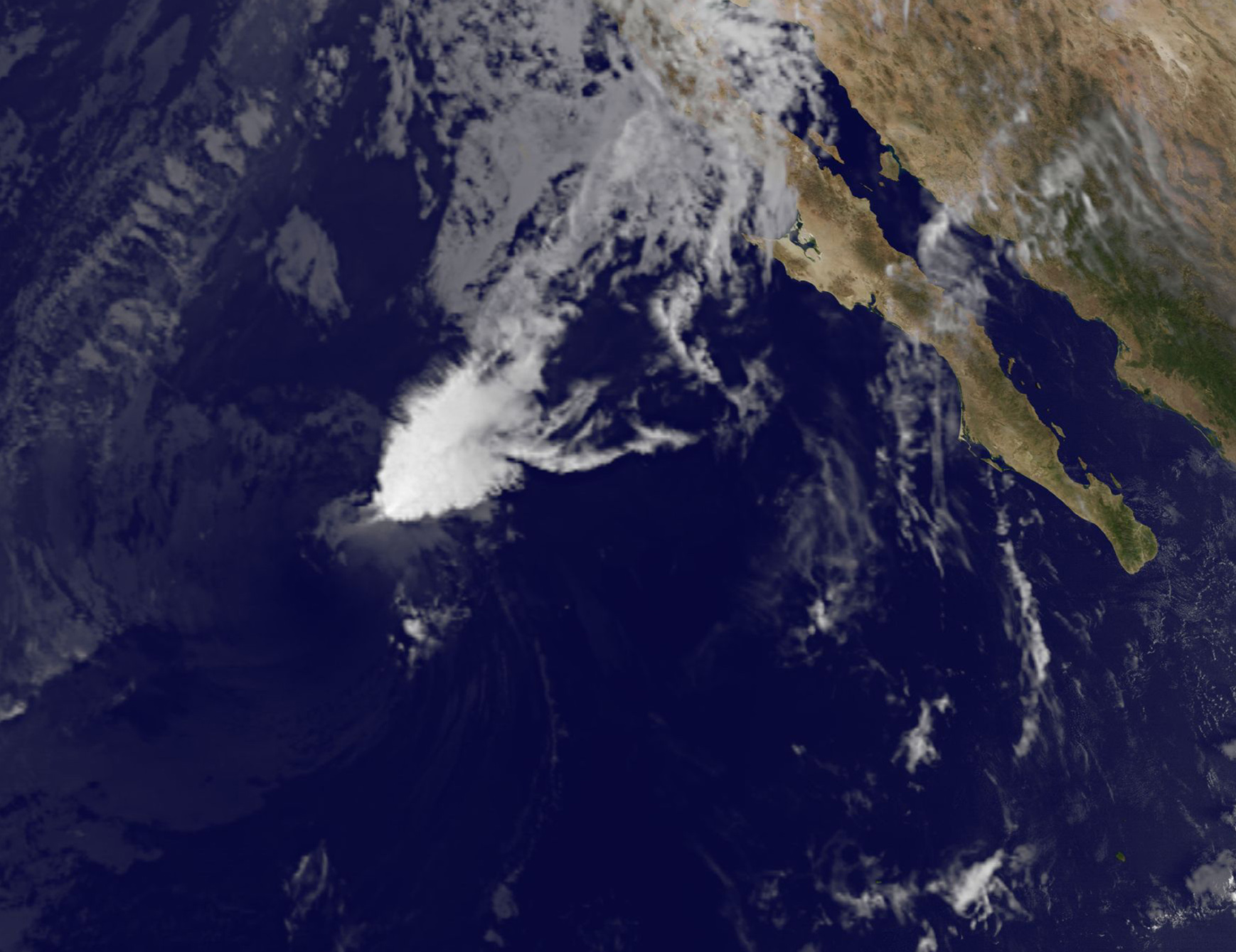
NOAA’s GOES-West satellite captured an infrared image of the remnant clouds associated with former Hurricane Seymour at 9:45 a.m. EDT (1345 UTC). The National Hurricane Center (NHC) issued their final advisory on the storm at 5 a.m. EDT when they noted that Seymour had become post-tropical.
Seymour’s remnants had no organized thunderstorm development when GOES-West captured an image of the storm. The storm actually resembled a wedge of clouds. The image was created by the NASA/NOAA GOES Project at NASA’s Goddard Space Flight Center, Greenbelt, Maryland.
National Hurricane Center (NHC) forecaster Richard Pasch said “The cyclone has lacked organized deep convection within 60-100 nautical miles of its center for over 12 hours, and no longer qualifies as a tropical cyclone. Since Seymour has become a post-tropical remnant low, advisories are being discontinued.”
At 5 a.m. EDT (0900 UTC), the center of Post-Tropical Cyclone Seymour was located near 22.4 degrees north latitude and 122.8 degrees west longitude. That’s about 820 miles (1,325 km) west of the southern tip of Baja California, Mexico. The post-tropical cyclone was moving toward the north near 8 mph (13 kph). NHC said a north-northeastward motion is expected to begin later today and continue into Saturday, Oct. 29. Maximum sustained winds have decreased to near 35 mph (55 kph) with higher gusts.
The NHC said the low pressure area will move through “an extremely hostile environment of strong southwesterly wind shear of 40-45 knots and sea surface temperatures cooler than 73.4 degrees Fahrenheit (23 degrees Celsius) during the next couple of days. Strong vertical wind shear can tear a storm apart, while sea surface temperatures cooler than 80 degrees Fahrenheit (26.6 degrees Celsius) are too cold to maintain a tropical cyclone. These environmental factors should cause the remnant low to dissipate in a couple of days.
Rob Gutro
NASA’s Goddard Space Flight Center
Oct. 27, 2016 – NASA’s Aqua Satellite Spots Hurricane Seymour on Fast Weakening Trend
NASA’s Aqua satellite passed Hurricane Seymour as it embarked on a fast weakening trend in the Eastern Pacific Ocean.
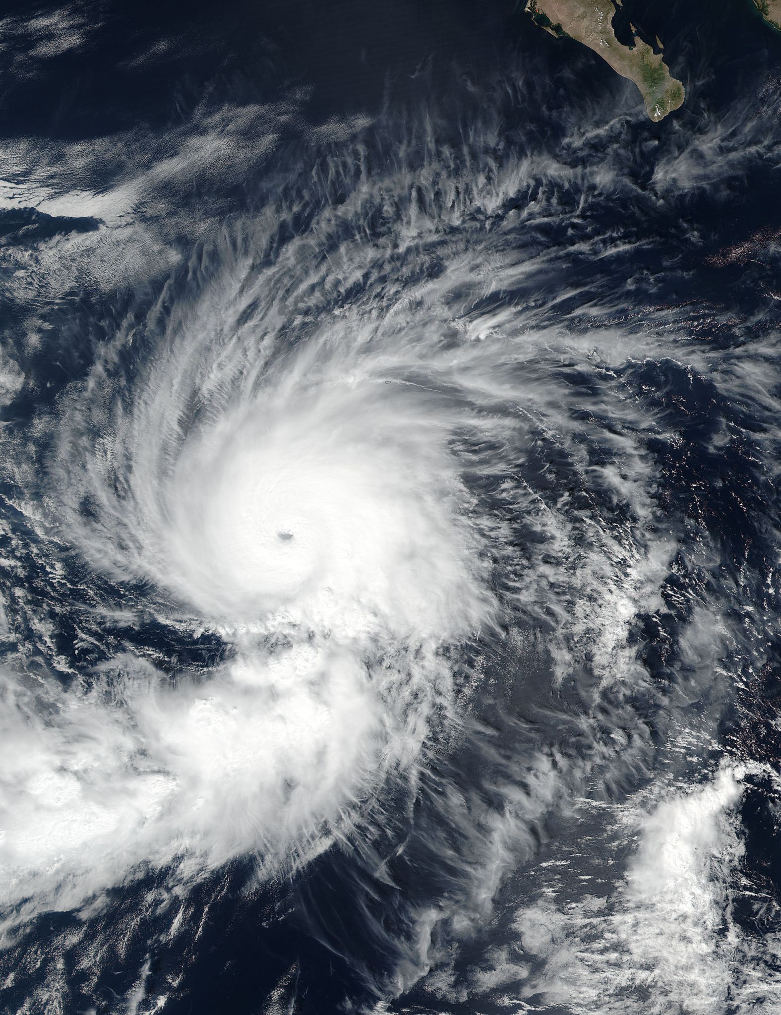
On Oct. 26 at 5:20 p.m. EDT (21:20 UTC) the Moderate Resolution Imaging Spectroradiometer or MODIS instrument aboard NASA’s Aqua satellite captured a visible light image of Hurricane Seymour that showed its eye had become cloud-filled. At the time maximum sustained winds had dropped to 125 mph (205 kph) and Seymour was weakening quickly.
The MODIS image showed the strongest thunderstorms were no longer symmetric in the storm. When a storm becomes asymmetric it’s a sign it’s weakening. To understand what happens when a tropical cyclone becomes asymmetric, think of a storm as a tire. If it isn’t rounded it doesn’t spin as fast.
At 5 a.m. EDT (0900 UTC) on Thursday, Oct. 27 the center of Hurricane Seymour was located near 19.5 degrees north latitude and 122.1 degrees west longitude. Seymour remains far from land and is centered about 820 miles (1,320 km) west-southwest of the southern tip of Baja California, Mexico.
The National Hurricane Center (NHC) said Seymour is moving toward the north-northwest near 12 mph (19 kph) and a turn to the north is expected today, followed by a northeastward motion on Friday, Oct. 28. The estimated minimum central pressure is 980 millibars.
Maximum sustained winds have decreased to near 90 mph (150 kph) with higher gusts. Rapid weakening is expected.
Seymour is forecast to weaken to a tropical storm this afternoon and become a remnant low pressure system on Friday.
For updated forecasts, visit the National Hurricane Center website: www.nhc.noaa.gov.
Rob Gutro
NASA’s Goddard Space Flight Center
Oct. 26, 2016 – NASA Provides a 3-D Look at Hurricane Seymour
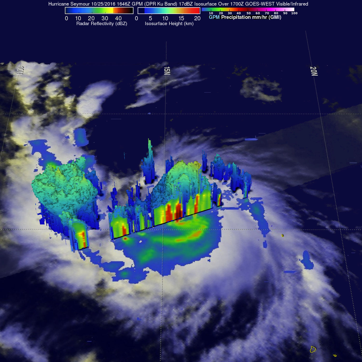
Hurricane Seymour became a major hurricane on Oct. 25 as the Global Precipitation Measurement mission or GPM core satellite analyzed the storm’s very heavy rainfall and provided a 3-D image of the storm’s structure.
Hurricane Seymour is the third hurricane in the Eastern Pacific this season to reach category four on the Saffir-Simpson hurricane wind scale. The pace of hurricane formation in the eastern Pacific Ocean is a slower than during El Nino conditions last year. In the 2015 season the 28th hurricane called Patricia had already occurred. Patricia was the second-most intense tropical cyclone on record worldwide with wind speeds of 187 knots (215 mph). Patricia hit the Mexican coast last year with winds of 150 mph.
The GPM core observatory satellite traveled directly over hurricane Seymour on the morning of October 25, 2016 at 7:46 am PDT (1646 UTC). GPM’s Microwave Imager (GMI) and Dual-Frequency Precipitation Radar (DPR) data were used to show the intensity of rainfall within Hurricane Seymour. GPM’s radar (DPR Ku Band) revealed that the hurricane had rain falling at the extreme rate of almost 166 mm (6.6 inches) per hour in the southern side of hurricane Seymour’s circular eye. GPM is a joint mission between NASA and the Japanese space agency JAXA.
On Oct. 25 at 4:35 p.m. EDT (20:35 UTC) the Visible Infrared Imaging Radiometer Suite (VIIRS) instrument aboard the NASA-NOAA Suomi NPP satellite captured a visible image of Hurricane Seymour as it became a Category 4 hurricane with maximum sustained winds near 130 mph (215 kph). The eye of the storm was clearly visible and was surrounded by thick, powerful bands of thunderstorms.
At 11 a.m. EDT (1500 UTC) on Oct. 26 the National Hurricane Center (NHC) reported the center of Hurricane Seymour was located near 16.9 degrees north latitude and 120.2 degrees west longitude. That’s about 785 miles (1,265 km) west-southwest of the southern tip of Baja California, Mexico.
Seymour is moving toward the west-northwest near 15 mph (24 kph) and a turn toward the northwest should occur later today, followed by a turn toward the north-northwest with a decrease in forward speed by Thursday, Oct. 27. A turn toward the north with a further reduction in forward speed is forecast by Oct. 28.
Maximum sustained winds have decreased to near 140 mph (220 kph) with higher gusts. Seymour is a category 4 hurricane on the Saffir-Simpson Hurricane Wind Scale. Further weakening is expected, and rapid weakening should begin by tonight or Thursday, Oct. 27. The estimated minimum central pressure is 949 millibars.
Credits: NASA/JAXA, Hal Pierce
NHC Forecaster Kimberlain said “Seymour continues to maintain an impressive central dense overcast, consisting of very deep convection around a 15 nautical mile wide well-defined eye. However, the distribution of convection has become slightly asymmetric since the last advisory, with the greatest coverage to the north and east of the center.”
Hurricane Seymour is beginning to move over colder water as it moves northward and start to weaken. Seymour is expected to become a depression over the open waters of the Eastern Pacific on Friday, Oct. 28.
For updated forecasts from NHC, visit: www.nhc.noaa.gov.
Hal Pierce / Rob Gutro
NASA’s Goddard Space Flight Center
Oct. 25, 2016 – NASA Sees Hurricane Seymour Becoming a Major Hurricane
Hurricane Seymour was strengthening into a major hurricane in the Eastern Pacific Ocean when the NASA-NOAA Suomi NPP satellite passed over it from space.
On Oct. 24 at 4:50 p.m. EDT (20:50 UTC) the Visible Infrared Imaging Radiometer Suite (VIIRS) instrument aboard NASA-NOAA’s Suomi NPP satellite provided a visible-light image of the storm. The image showed tight bands of thunderstorms wrapped around the low-level center of circulation and a large band of powerful thunderstorms wrapped into the center from the western quadrant. At time Suomi NPP passed overhead, Seymour was a Category 2 hurricane as maximum sustained winds rapidly increased to near 100 mph (155 kph)
Within the hour after Suomi NPP passed overhead, Forecaster Kimberlain of the National Hurricane Center (NHC) noted “Seymour is rapidly intensifying. A pinhole eye has formed within a small, nearly symmetric, central dense overcast (CDO) during the last several hours. In addition, a long curved band coils inward toward the center with a dry slot between it and the CDO.”
Seymour continued to quickly intensify. By 5 a.m. EDT (0900 UTC) on Oct. 25 Seymour became a major hurricane, attaining Category 3 status on the Saffir-Simpson Hurricane Wind Scale. The maximum sustained winds have increased to near 115 mph (185 kph) with higher gusts. Additional strengthening is expected today, but Seymour is forecast to begin weakening on Wednesday, Oct. 26.
At that time, the NHC said the small eye of Hurricane Seymour was located near 15.6 degrees north latitude and 113.8 degrees west longitude. That puts the eye of the storm about 565 miles (910 km) south-southwest of the southern tip of Baja California, Mexico.
Seymour is moving toward the west near 15 mph (24 kph). A west to west-northwest motion is expected through tonight. A turn toward the northwest is forecast to occur on Wednesday.
For updates on Seymour, visit the NHC website: www.nhc.noaa.gov.
Rob Gutro
NASA’s Goddard Space Flight Center
Oct. 24, 2016 – NASA Animation Shows Seymour Becomes a Hurricane
Tropical Depression 20 formed in the Eastern Pacific Ocean on Sunday and by Monday at 11 a.m. it exploded into a hurricane named Seymour. An animation of satellite imagery created by NASA shows the development of the new hurricane.
Credits: NASA/NOAA GOES Project
The twentieth tropical depression of the Eastern Pacific Ocean hurricane season formed on Sunday, Oct. 23 at 5 a.m. EDT.
National Hurricane Center Forecaster Kimberlain said “Seymour’s cloud pattern continues to increase in organization. The cyclone’s small central dense overcast has become circular and increasingly symmetric since the last advisory, with plenty of cold-topped deep convection, particularly near the center.”
NOAA’s GOES-West satellite captured infrared and visible imagery that showed the rapid intensification of the storm over 30 hours. An animation of data, created at NASA’s Goddard Space Flight Center in Greenbelt, Maryland that spans from Oct. 21 to early on Oct. 24 shows the development of Tropical Depression 20 and explosive growth into Hurricane Seymour on Oct. 24.
At 11 a.m. EDT (1500 UTC) on Oct. 24 the center of Hurricane Seymour was located near 15.2 degrees north latitude and 109.8 degrees west longitude. That puts the center of the depression about 450 miles (720 km) south of Manzanillo, Mexico.
The National Hurricane Center (NHC) said that Seymour is moving toward the west-northwest near 15 mph (24 kph), and this motion with some decrease in forward speed is expected during the next couple of days. Maximum sustained winds have increased to near 75 mph (120 kph) with higher gusts. Additional strengthening is likely, and Seymour is expected to become a major hurricane on Tuesday, Oct. 25.
For updated forecasts, visit: www.nhc.noaa.gov


