Extreme rain events fueled by the current strong El Nino have started to affect California. NASA estimated rainfall over a period of 7 days while NASA/NOAA’s GOES Project created a satellite animation showing the storms affecting the region over the past three days.
Credits: NASA/NOAA GOES Project
An animation NOAA’s GOES-West satellite imagery from Jan. 5 through Jan 7 shows the progression of storm systems in the Eastern Pacific Ocean that hit southern California and generated flooding and mudslides. The animation was created at NASA’s Goddard Space Flight Center in Greenbelt, Maryland.
An estimate of rainfall totals from December 31, 2015 to the morning (EST) on January 6, 2016 was made using data from NASA’s Integrated Multi-satellitE Retrievals for GPM (IMERG) for a series of storms moving over the Eastern Pacific toward the U.S. West coast. Global precipitation estimates are provided by IMERG through the use of data from satellites in the Global Precipitation Measurement (GPM) mission constellation and is calibrated with measurements from the GPM Core Observatory as well as rain gauge networks around the world. GPM is a satellite managed by both NASA and the Japan Aerospace Exploration Agency.
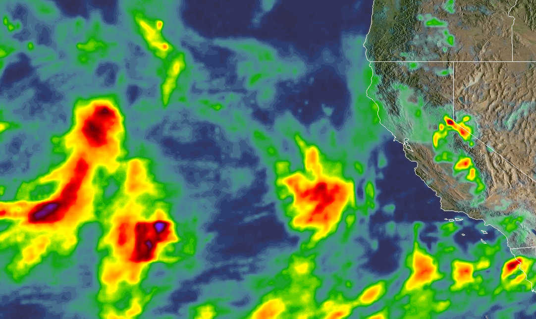
The IMERG data showed highest rainfall totals over the eastern Pacific Ocean of more than 4.5 inches (114.3 mm) and highest totals over land near Lake Tahoe and the west central Nevada border at more than 4 inches (101.6 mm).
The Integrated Multi-satellitE Retrievals for GPM (IMERG) creates a merged precipitation product from the GPM constellation of satellites. These satellites include DMSPs from the U.S. Department of Defense, GCOM-W from the Japan Aerospace Exploration Agency (JAXA), Megha-Tropiques from the Centre National D’etudies Spatiales (CNES) and Indian Space Research Organization (ISRO), NOAA series from the National Oceanic and Atmospheric Administration (NOAA), Suomi-NPP from NOAA-NASA, and MetOps from the European Organisation for the Exploitation of Meteorological Satellites (EUMETSAT). All of the instruments (radiometers) onboard the constellation partners are intercalibrated with information from the GPM Core Observatory’s GPM Microwave Imager (GMI) and Dual-frequency Precipitation Radar (DPR).
The precipitation shown in the IMERG product along the western slopes of the Sierra Nevada Mountains is providing snowfall that is crucial to alleviating the drought driven low water reserves in California.
On Jan. 8, NWS Weather Prediction Center in College Park Md. noted that the upper-level low pressure area is forecast to move across the Four Corners region, bringing snow to the higher terrain of the Southwest and to portions of the southern and central Rockies. Portions of the Mogollon Rim as well as the Rockies in southern Colorado and northern New Mexico have the potential for heavy snow, with snowfall amounts of one foot possible at the highest elevations.
Another Pacific frontal system is approaching the West Coast to bring rain and high elevation snows to the West Coast states. For updated forecasts, visit the National Weather Service website at: www.weather.gov.
Hal Pierce / Rob Gutro
NASA’s Goddard Space Flight Center

