Aug. 8, 2016 – NASA’s IMERG Measures Hurricane Earl’s Deadly Rainfall in Mexico
Data from NASA’s Integrated Multi-satellite Retrievals for GPM (IMERG) were used to estimate the amount of rain that fell from Earl Aug. 2 through Aug. 8.
Aug. 5, 2016 – NASA Sees Tropical Storm Earl Over Mexico
Hurricane Earl began as a tropical wave that was tracked by the National Hurricane Center (NHC) from the African coast to the Caribbean Sea. The tropical wave drenched the Dominican Republic, where it was blamed for the deaths of six people. Southwest of Jamaica on Aug. 2, 2016, the tropical wave developed a closed circulation, and Earl was upgraded to a tropical storm.
On Aug. 3, Earl became a hurricane when it was located about 150 miles east of Belize. On Aug. 4 Earl made landfall just southwest of Belize City, Belize, at about 2 a.m. EDT (6 a.m. UTC). At landfall Earl had winds of about 81 mph (70 knots). Earl weakened to tropical depression intensity over the Yucatan but regained tropical storm wind speeds of about 58 mph (50 knots) when it emerged over the Bay of Campeche. On Aug. 6, Earl hit Mexico again just south of Veracruz. Earl was then disrupted by Mexico’s rough terrain and dissipated.
Data from NASA’s Integrated Multi-satellite Retrievals for GPM (IMERG) were used to estimate the amount of rain that fell from Aug. 2 through Aug. 8. GPM is the Global Precipitation Measurement mission, a joint mission of NASA and the Japan Aerospace Exploration Agency.
The analysis, created at NASA’s Goddard Space Flight Center in Greenbelt, Maryland, showed rainfall over the period from when Earl became a tropical storm until Earl’s remnants interacted with an area of disturbed weather along the Pacific coast. Some areas in extreme southern Mexico received up to 43.3 inches (1,100 mm) of rain.
The IMERG analysis showed the extreme amount of rain that was dropped by Earl over Belize, Guatemala, eastern Mexico and Mexico’s Pacific coast.
According to the official Twitter account of Luis Puente, Mexico’s national civil protection coordinator, at least 40 people were reported killed by landslides in the Mexican states of Puebla and Veracruz.
The remnants of Earl interacted with an area of disturbed weather along the Pacific coast of Mexico and aided in the formation of a tropical depression that became Tropical Storm Javier on Aug. 7.
Aug. 5, 2016 – NASA Sees Tropical Storm Earl Over Mexico
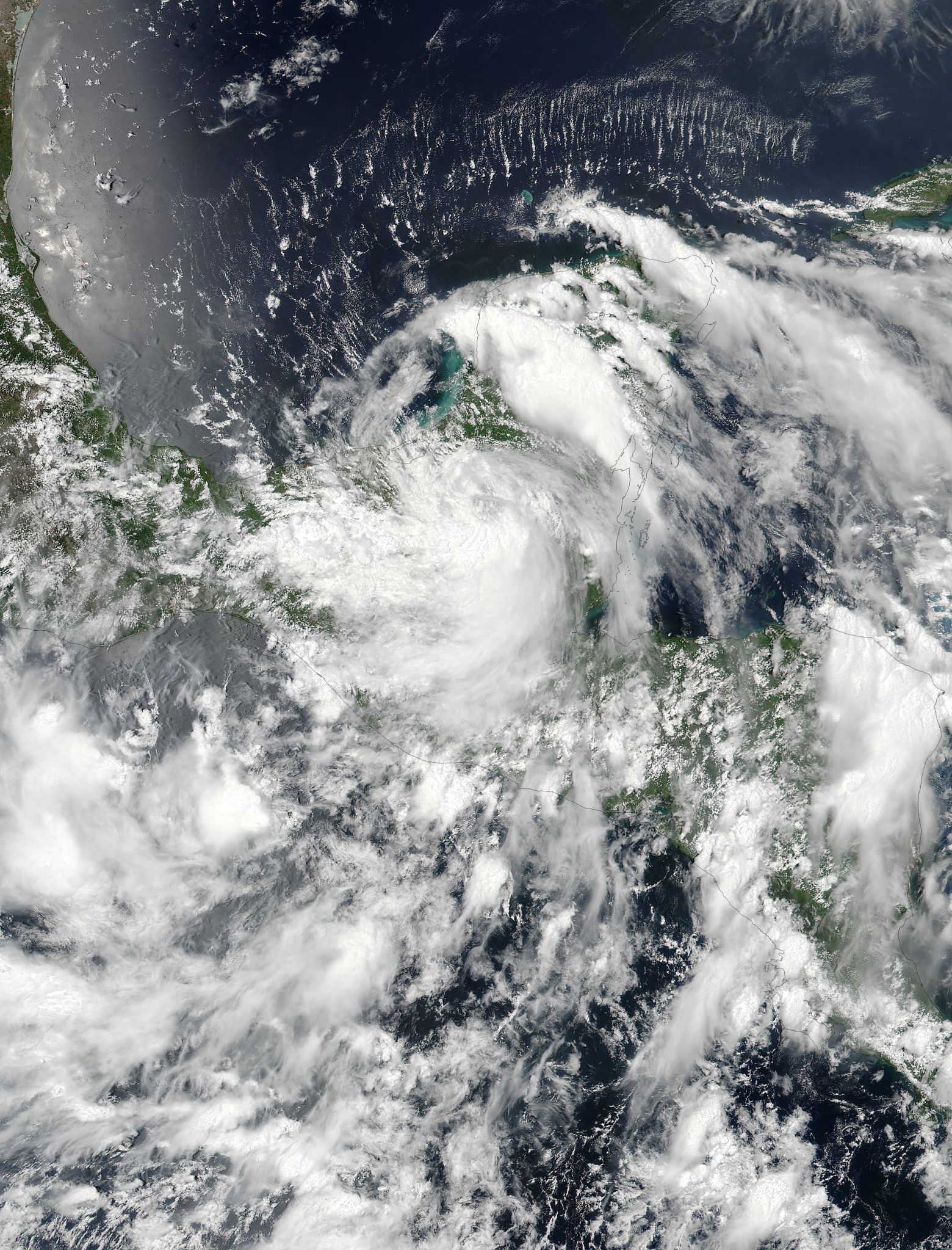
Tropical Storm Earl made landfall as a Category 1 hurricane in Belize on Aug. 4, and NASA-NOAA’s Suomi NPP satellite saw the storm move over Mexico’s Yucatan Peninsula the next day.
On Aug. 4 at 3:30 p.m. EDT (19:30 UTC) the Visible Infrared Imaging Radiometer Suite (VIIRS) instrument aboard NASA-NOAA’s Suomi NPP satellite captured a visible-light image of Earl over the Yucatan. The VIIRS image showed that Earl still had thunderstorms around its center of circulation, but bands of thunderstorms around the center were fragmented.
On Aug. 5 a tropical storm warning is in effect for Ciudad del Carmen westward to Laguna Verde, Mexico, as Earl was hugging the coast of the Bay of Campeche.
At 8 a.m. EDT (1200 UTC) the center of Tropical Storm Earl was estimated near 18.5 north latitude and 93.5 west longitude. That put Earl’s center just 65 miles (105 km) east-northeast of Coatzacoalcos, Mexico.
Earl is moving toward the west-northwest at near 12 mph (19 kph). The National Hurricane Center forecasts a turn toward the west and a decrease in forward speed later today (Aug. 5). On the forecast track, the center of Earl will be moving near the coast along the extreme southern Bay of Campeche today and tonight. Earl will then move into southeastern mainland Mexico on Saturday, Aug. 6.
Maximum sustained winds remain near 40 mph (65 kph) with higher gusts. Little change in strength is likely today or tonight, with weakening expected on Saturday when Earl moves into mainland Mexico.
For updated forecasts from NHC, visit: www.nhc.noaa.gov
By Rob Gutro
NASA’s Goddard Space Flight Center, Greenbelt, Md.
Aug. 4, 2016 – Satellite Animation Shows Landfall of Hurricane Earl in Belize
A NASA satellite animation of imagery from NOAA’s GOES-East satellite shows the movement and landfall of Hurricane Earl near Belize City, Belize.
Credits: NASA/NOAA GOES Project
NOAA’s GOES-East satellite has been providing visible and infrared data on Hurricane Earl since its development as a tropical depression on Aug. 2. At NASA’s Goddard Space Flight Center in Greenbelt, Maryland, the NASA/NOAA GOES project combined the data into an animation that showed the movement and strengthening of Earl from Aug. 2 to Aug. 4 through the Caribbean Sea.
At 1 a.m. EDT on Thursday, Aug. 4, 2016 reports from an Air Force Reserve Hurricane Hunter aircraft indicated Earl’s maximum sustained winds increased to near 80 mph (130 kph) making it a hurricane. At 2 a.m. EDT Hurricane Earl made landfall 5 miles southwest of Belize City, Belize.
By 11 a.m. EDT on Aug. 4, Earl was inland and already 115 miles (185 km) west of Belize City and had weakened to a tropical storm. The Government of Belize has discontinued all coastal warnings. There are no coastal watches or warnings in effect. Interests along the southern Bay of Campeche should monitor the progress of Earl.
The center of Tropical Storm Earl was located well inland near 17.2 degrees north latitude and 89.9 degrees west longitude. Earl was moving toward the west near 12 mph (19 kph), and the National Hurricane Center (NHC) said this general motion is expected to continue during the next couple of days. On the forecast track, NHC said Earl will continue to move across northern Guatemala and southeastern Mexico tonight and Friday. The estimated minimum central pressure is 990 millibars.
Maximum sustained winds have decreased to near 50 mph (85 kph) with higher gusts. Additional weakening is expected as the center moves over high terrain, and Earl is forecast to weaken to a tropical depression by tonight.
In the NHC discussion, Forecaster Lixion Avila wrote: “Earl is already well inland over northern Guatemala, and although visible satellite images still show a vigorous circulation, the convection is rapidly decreasing. There are no wind observations near the center, but the best estimate of the initial intensity is 45 knots. Since most of the circulation of Earl is forecast to move over the high terrain of Guatemala and southeastern Mexico, rapid weakening is anticipated. Earl is expected to degenerate into a tropical depression tonight and into a remnant low in a day or so.”
For additional updates, visit the NHC website at: www.nhc.noaa.gov.
By Rob Gutro
NASA’s Goddard Space Flight Center, Greenbelt, Md.
Aug. 3, 2016 – NASA’s GPM Sees Towering Thunderstorms in Intensifying Tropical Storm Earl
Tropical storm Earl has been intensifying as it moves through the Caribbean Sea. The GPM satellite spotted hot towers, towering thunderstorms within Earl that indicate the storm may intensify.
Credits: NASA/JAXA/SSAI, Hal Pierce
The National Hurricane Center (NHC) now predicts that Earl will be a hurricane before it hits Mexico’s Yucatan Peninsula tomorrow afternoon. Earl is predicted by NHC to remain in a light to moderate vertical wind shear environment over very warm sea surface temperatures until landfall.
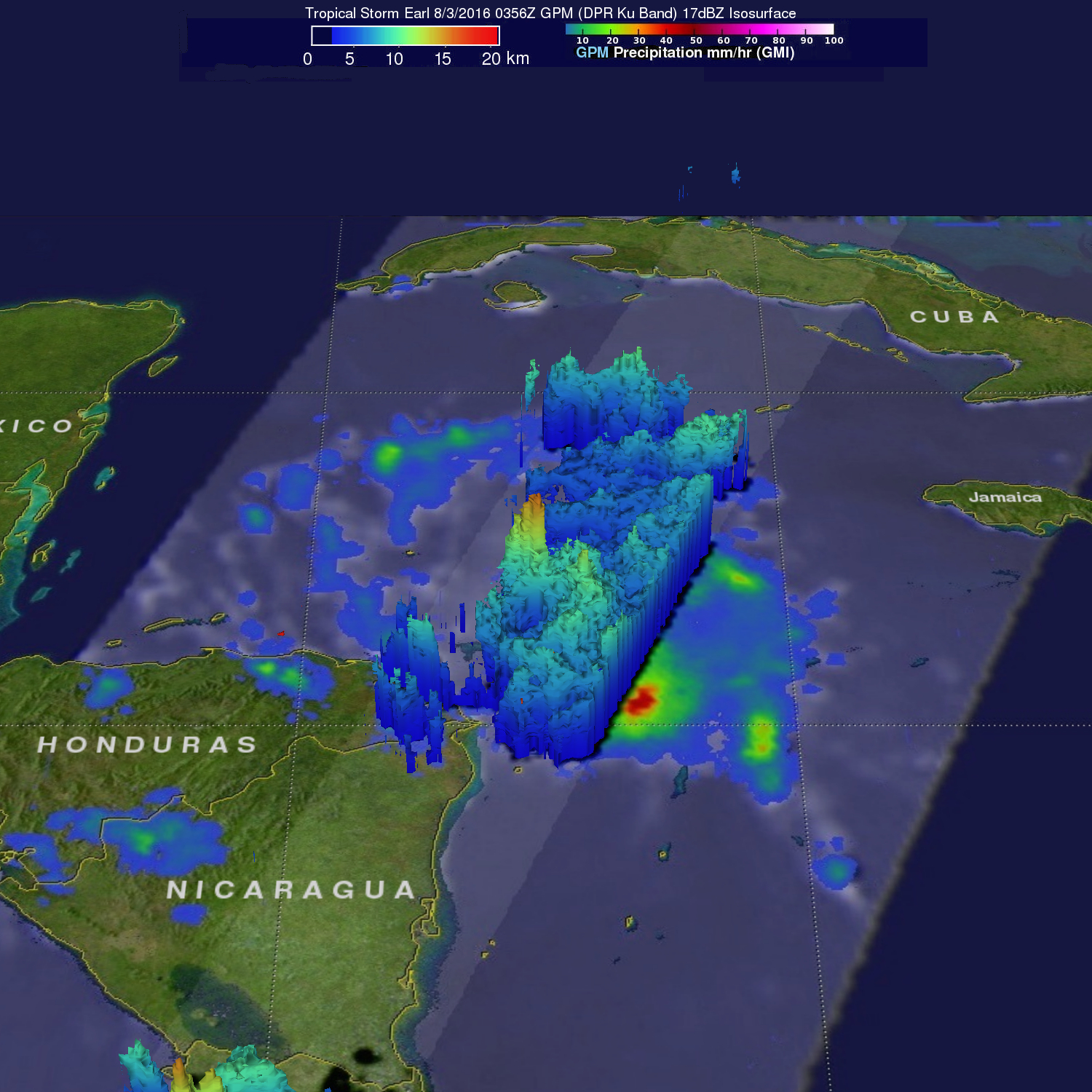
The Global Precipitation Measurement mission or GPM core observatory satellite passed over intensifying tropical storm Earl in the Caribbean Sea northeast of Honduras on Aug. 2, 2016 at 11:56 p.m. EDT (Aug. 3, 2016 at 0356 UTC). GPM’s Microwave Imager (GMI) and Dual-Frequency Precipitation Radar (DPR) showed that powerful storms around Earl’s forming eye were dropping extremely heavy rainfall. DPR found that rain was falling at a rate of over 251 mm (9.8 inches) per hour in a band of powerful convective storms.
GPM’s Radar (DPR Ku band) were used to show in 3-D the towering thunderstorms near Earl’s center reaching heights of over 16 km (9.9 miles). These strong thunderstorms called “hot towers” often lead to rapid intensification in a tropical cyclone. NASA research has shown that whenever there is the presence of hot towers, the storm usually intensifies within six hours. GPM is a joint mission between NASA and the Japan Aerospace Exploration Agency.
On Aug. 3, 2016 a hurricane warning is in effect for Puerto Costa Maya, Mexico, southward to the Belize/Guatemala border and for the Bay Islands, Honduras. A tropical storm warning is in effect for the north coast of Honduras from Cabo Gracias a Dios westward to the Honduras/Guatemala border and north of Puerto Costa Maya to Punta Allen, Mexico.
The heavy rainfall rates seen by GPM are evident in the forecast from the National Hurricane Center (NHC). The NHC forecast noted that Earl is expected to produce total rain accumulations of 8 to 12 inches over portions of Belize, Honduras, Guatemala, and the Yucatan peninsula of Mexico through Thursday night. Very heavy rain will reach the Mexican states of Tabasco and Veracruz between Thursday night and Saturday morning. Isolated maximum amounts of 16 inches are possible in Belize and Mexico.
At 2 p.m. EDT (1800 UTC), the center of Tropical Storm Earl was located near latitude 16.8 North, longitude 85.6 West. Earl is moving toward the west near 14 mph (22 kph), and this general motion is expected to continue with some decrease in forward speed during the next 48 hours. On the forecast track, the core of Earl is expected to pass near the Honduras Bay Islands this afternoon, and then make landfall in Belize tonight or early Thursday.
Maximum sustained winds remain near 70 mph (110 kph) with higher gusts. Additional strengthening is forecast during the next 12 hours or so, and Earl is expected to be a hurricane by the time it makes landfall along the coast of Belize.
For updated forecasts, visit NHC: www.nhc.noaa.gov.
By Hal Pierce / Rob Gutro
NASA’s Goddard Space Flight Center, Greenbelt, Md.
Aug. 3, 2016 – NASA Sees Tropical Storm Earl Poised for Landfall in Belize
Tropical Storm Earl developed on Tuesday, August 2 and NASA satellites provided data that showed the storm was strengthening quickly. The National Hurricane Center forecasts Earl to reach hurricane strength late on August 3 as it approaches Belize.
On August 2 a tropical wave in the Caribbean Sea south of Cuba developed a closed circulation center and was then designated tropical storm Earl by the National Hurricane Center (NHC). Earl is the fifth tropical cyclone to form in the Atlantic Ocean this year.
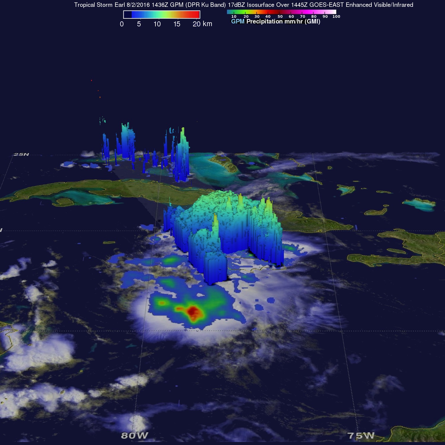
The Global Precipitation Measurement mission or GPM core observatory satellite flew over the forming tropical storm on August 2, 2016 at 10:36 a.m. EDT (14:36 UTC). GPM’s Microwave Imager (GPM) and Dual-Frequency Precipitation Radar (DPR) data were used in an analysis to show precipitation accompanying Earl. GPM’s GMI provided excellent coverage of heavy convective rainfall in the Caribbean Sea south of Jamaica.
GPM’s DPR data swath examined convective storms northeast of Earl’s center of circulation. DPR measured precipitation in some of these storms falling at a rate of over 118 mm (4.6 inches) per hour.
GPM’s Radar (DPR Ku Band) showed the 3-D structure of rainfall in the storms around Jamaica. Storm top heights in some energetic convective storms were found to reach heights of over 15 km (9.3 miles). GPM is a joint mission between NASA and the Japanese Space Agency.
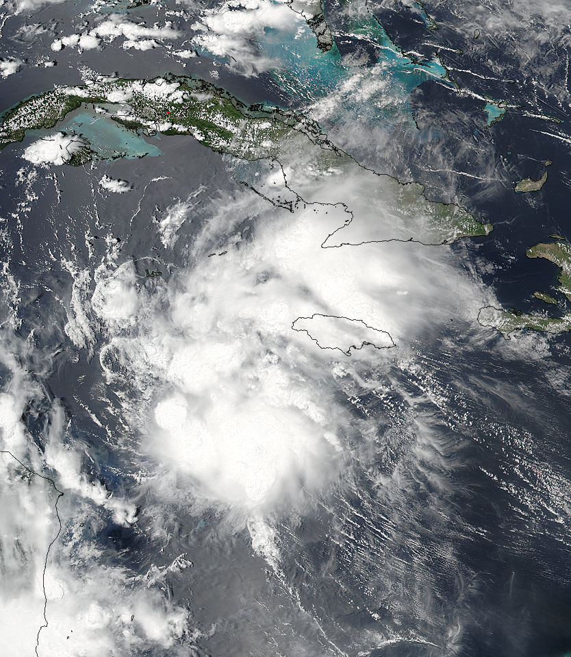
The Visible Infrared Imaging Radiometer Suite (VIIRS) instrument aboard the NASA-NOAA Suomi NPP satellite captured a visible light image of Tropical Storm Earl on Aug. 2 at 2:30 p.m. EDT (18:30 UTC). The VIIRS image showed banding of clouds and showers wrapping into the low level center of circulation. VIIRS collects visible and infrared imagery and global observations of land, atmosphere, cryosphere and oceans.
NHC forecaster Beven said that on August 2 at 9 p.m. EDT microwave satellite imagery indicated that Earl has formed a mid-level eye. Beven said that satellite data also suggested that circulation center had reformed to the south of the previous forecast track underneath the eye feature. The latest satellite imagery suggests that the track excursion caused by the reformation is over.
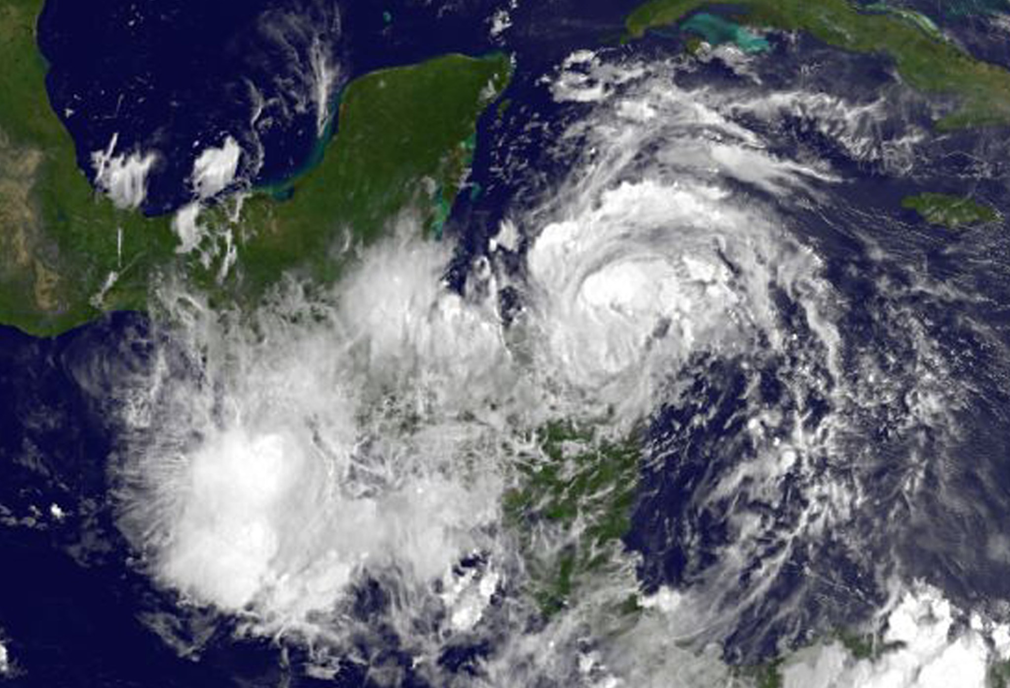
NOAA’s GOES-East satellite captured an infrared image of Tropical Storm Earl just north of the Honduras coast on Aug. 3 at 7:45 a.m. EDT. The image showed bands of thunderstorms wrapping around the northern quadrant of the storm. NOAA manages the GOES series of satellites and the NASA/NOAA GOES Project at NASA’s Goddard Space Flight Center in Greenbelt, Maryland, uses the satellite data to create images and animations.
On August 3, a Hurricane Warning was in effect for Puerto Costa Maya, Mexico, southward to the Belize/Guatemala border, and the Bay Islands, Honduras. A Tropical Storm Warning is in effect for north coast of Honduras from Cabo Gracias a Dios westward to the Honduras/Guatemala border. Tropical Storm Warning is also in effect from north of Puerto Costa Maya to Punta Allen, Mexico.
At 8 a.m. EDT (12:00 UTC) on August 3 the center of Tropical Storm Earl was located near 16.3 degrees north latitude and 84.4 degrees north longitude. That’s about 120 miles (195 km) east of Roatan Island, Honduras, and 265 miles (425 km) east-southeast of Belize City, Belize.
Earl is moving toward the west near 14 mph (22 km/h), and this general motion is expected to continue with some decrease in forward speed during the next 48 hours.
Maximum sustained winds have increased to near 70 mph (110 kph) with higher gusts. Additional strengthening is forecast by NHC during the next 24 hours, and Earl is likely to become a hurricane later today. Weakening is expected after the center of Earl moves inland. Tropical-storm-force winds extend outward up to 90 miles (150 km) from the center.
The minimum central pressure recently estimated by a NOAA Hurricane aircraft was 989 millibars.
On the forecast track, the core of Earl is expected to pass near the Honduras Bay Islands during the afternoon on Wednesday, August 3 and then make landfall in Belize at night or early Thursday, August 4.
For the latest forecasts on Earl, visit the National Hurricane Center website: www.nhc.noaa.gov.
By Rob Gutro
NASA’s Goddard Space Flight Center, Greenbelt, Md.
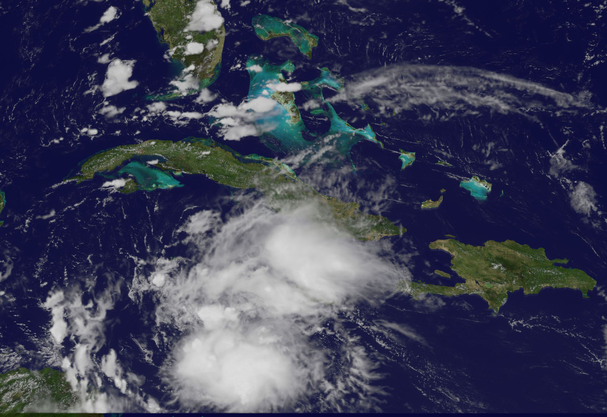
August 2, 2016 – Tropical Storm Earl Forms in Caribbean Sea
The fifth tropical cyclone of the Atlantic Ocean hurricane season formed today in the Caribbean Sea. NOAA’s GOES-East satellite provided a look at the storm as hurricane-hunter aircraft confirmed a closed circulation.
Tropical Storm Earl formed in the Caribbean Sea and is forecast to move west over the next couple of days. As a result, the government of Honduras has issued a tropical storm warning for the entire north coast of Honduras from Cabo Gracias a Dios westward to the Honduras-Guatemala border including the Bay Islands.
In addition, a hurricane watch is in effect for the east coast of Mexico’s Yucatan Peninsula from Punta Allen southward to the Belize-Guatemala border.
At 12 p.m. EDT (4 p.m. UTC) on Tuesday, Aug. 2, 2016, the center of Earl was located near 16.3 degrees north latitude and 80.2 degrees west longitude.
NOAA’s National Hurricane Center said that Earl is moving toward the west near 22 mph (35 kph), and this motion with a decrease in forward speed is expected during the next couple of days. On this track, the center of Earl will be moving very close to the north coast of Honduras late tonight and Wednesday and approach Belize and the Yucatan peninsula late Wednesday.
Maximum sustained winds are near 45 mph (75 kph) with higher gusts. Some additional strengthening is forecast before Earl reaches the Yucatan Peninsula. The minimum central pressure estimated from an Air Force plane was 1,001 millibars.
NOAA’s GOES-East satellite captured a visible image of Earl at 1:30 p.m. EDT (5:30 p.m. UTC). Earl is a small storm, as tropical-storm-force winds extend outward up to 80 miles (130 km) from the center. The GOES-East image showed that an area of deep convection (rising air that forms the thunderstorms that make up a tropical cyclone) is forming near or over the center. The image was created by the NASA/NOAA GOES Project at NASA’s Goddard Space Flight Center in Greenbelt, Maryland.
For updates on Earl, visit the NHC website at: www.nhc.noaa.gov.
By Rob Gutro
NASA’s Goddard Space Flight Center, Greenbelt, Md.

