


Dolores (Eastern Pacific)
Credits: NASA/NOAA GOES Project
Rob Gutro
NASA’s Goddard Space Flight Center
July 20, 2015 – NASA Sees Tropical Storm Dolores Weakening
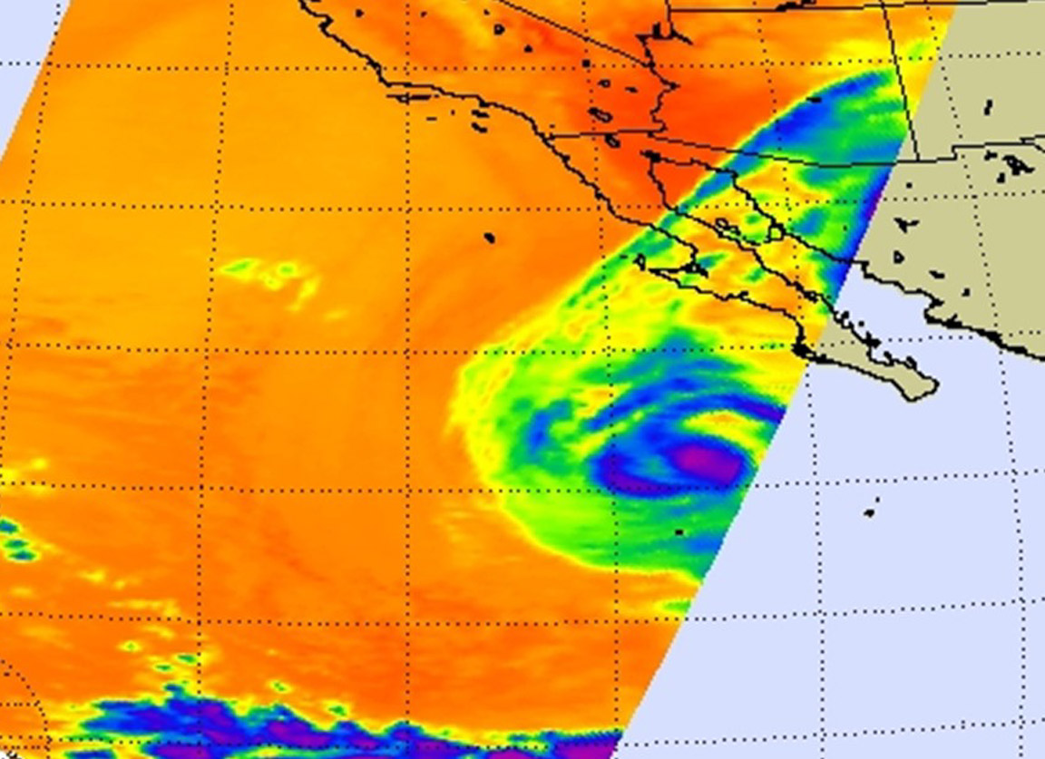
Hurricane Dolores weakened to a tropical storm early on July 17 as NASA’s Aqua satellite passed overhead and gathered infrared information about the storm.
The Atmospheric Infrared Sounder or AIRS instrument that flies aboard NASA’s Aqua satellite showed cloud top temperatures in Dolores were as cold as -63F/-52C on July 17 at 5:47 a.m. EDT, around the center of circulation and a band of thunderstorms in the western quadrant. Most of the cloud tops around the edges of the storm were warmer, indicating they were lower in the atmosphere and likely weaker thunderstorms.
On July 17, 2015 at 11 a.m. EDT (1500 UTC), the center of Tropical Storm Dolores was located near latitude 21.4 North, longitude 115.1 West. Dolores was moving toward the west-northwest near 9 mph (15 kph), and Dolores is expected to turn to the north-northwest by Sunday, July 19. Maximum sustained winds have decreased to near 70 mph (110 kph) and additional weakening is forecast during the next two days. The estimated minimum central pressure is 989 millibars.
As Dolores continues to pull away from Mexico, swells generated by the tropical storm are affecting portions of the coast of southwestern Mexico and the west coast of the Baja California peninsula. Those swells are expected to reach the coast of southern California later today, July 17 and on July 18.
The National Hurricane Center said that “steady weakening is expected to continue due to even colder water and an increase in vertical [wind] shear in about [2 days], and Dolores is likely to become a remnant low in a few days.”
Rob Gutro
NASA’s Goddard Space Flight Center
July 16, 2015 – NASA Spots Hurricane Dolores Over Socorro Island
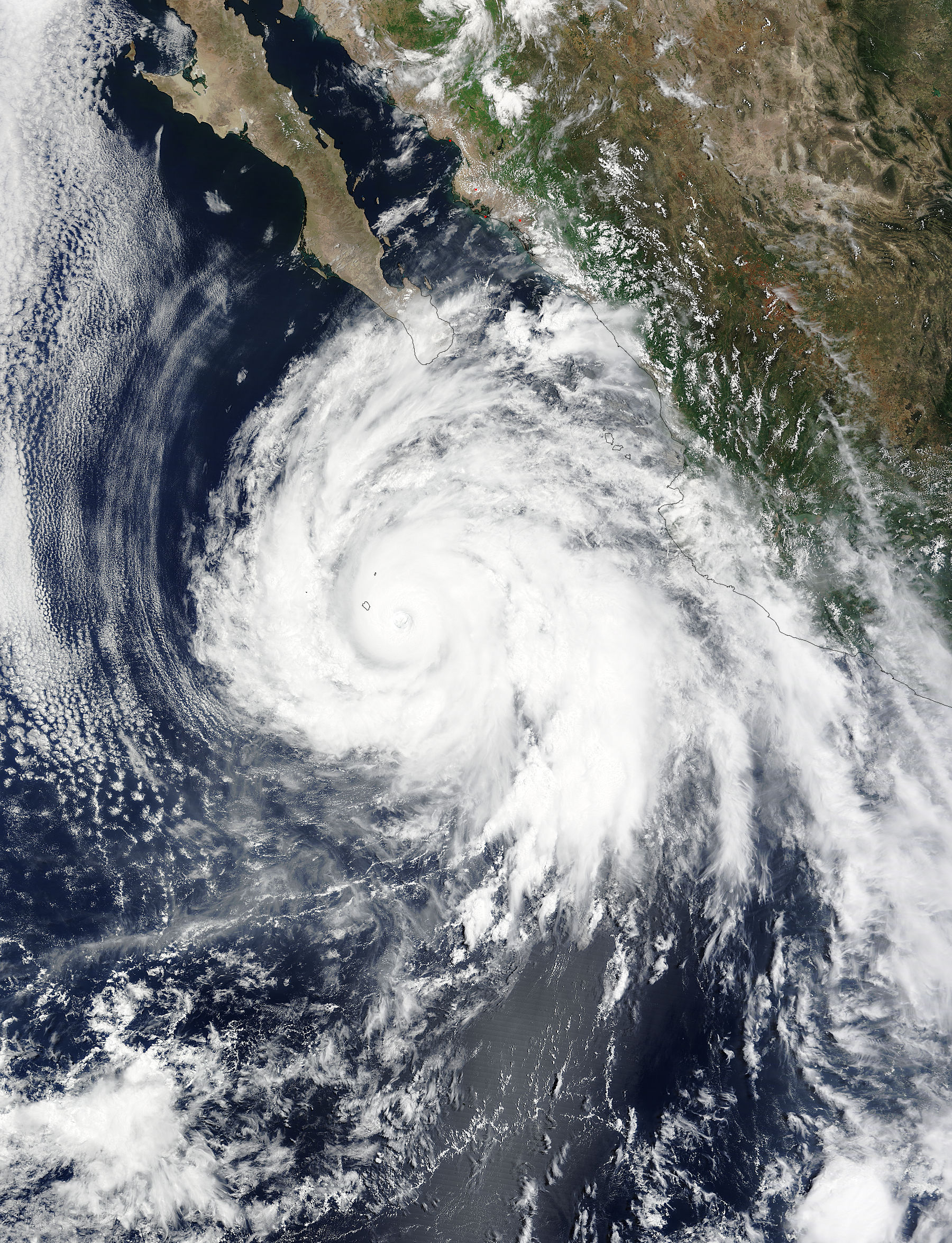
Hurricane Dolores moved over Socorro Island on July 15 as NASA’s Terra satellite passed overhead. On July 16, the island was still feeling the effects of Dolores.
Socorro Island is a small volcanic island in Mexico’s Revillagigedo Islands. Socorro is about 370 miles (~600 kilometers) west of the west coast of Mexico. There is a naval station on the island.
On July 15 at 17:55 UTC the MODIS instrument aboard NASA’s Terra satellite captured a visible image of Hurricane Dolores in the Eastern Pacific Ocean that showed the western quadrant of the storm moving over Socorro Island. Dolores’ eye was still visible, although it had become mostly cloud-filled at the time of the image.
On July 16 at 11 a.m. EDT (1500 UTC), the eye of Hurricane Dolores was located near latitude 19.9 North, longitude 111.8 West. Maximum sustained winds remain near 115 mph (185 kph) with higher gusts. Dolores is a category 3 hurricane on the Saffir-Simpson Hurricane Wind Scale. The National Hurricane Center (NHC) reported that gusts to tropical storm force were still occurring on Socorro Island a couple of hours ago but should continue to diminish during the day.
Dolores was moving toward the northwest near 7 mph (11 kph). NHC forecasts a west-northwestward to northwestward motion with some increase in forward speed through early Saturday. The estimated minimum central pressure is 960 millibars.
Dolores is still generating rough surf along the southwestern coast of Mexico as it continues to pull away from land. Swells generated by Dolores are affecting portions of the coast of southwestern Mexico and Baja California Sur. These swells could cause life-threatening surf and rip current conditions.
Gradual weakening is expected to begin later on July 16. At 11 a.m. EDT on July 16, NHC’s forecaster Berg noted that Dolores has another 24 hours or so before it reaches sea surface temperatures cooler than 26.6 Celsius (80 Fahrenheit) needed to maintain the storm. Berg said that given the hurricane’s structure, only gradual weakening is anticipated in the short term.
After that, Dolores is forecast to move through colder water which will sap the convection (rising air that forms the thunderstorms that make up a tropical cyclone). The storm will also move into an area with increasing vertical wind shear (winds that can tear a storm apart) and into drier air, which will also limit or prevent thunderstorm development. The extended forecast calls for Dolores to become a remnant low pressure area by July 21.
Rob Gutro
NASA’s Goddard Space Flight Center
July 15, 2015 – NASA’s Aqua Satellite Sees Hurricane Dolores Moving Away from Mexico
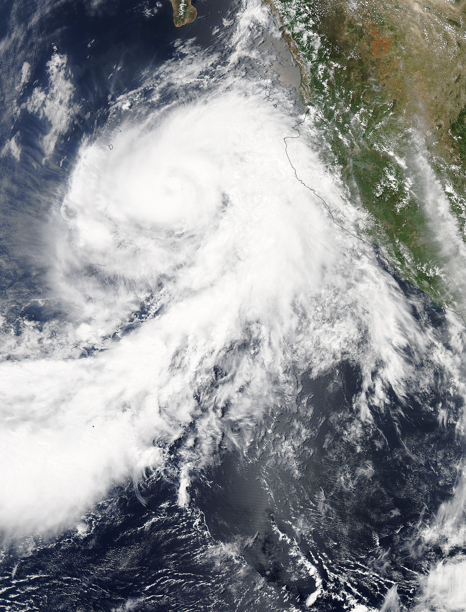
NASA’s Aqua satellite flew over Hurricane Dolores in the Eastern Pacific Ocean as it continued to move away from the southwestern coast of Mexico. Dolores was still a Category 4 hurricane and was generating rough surf and ocean swells.
The National Hurricane Center (NHC) noted on July 15 that “swells generated by Dolores are affecting portions of the coast of southwestern Mexico and the southern coast of the Baja California peninsula. These swells could cause life-threatening surf and rip currents.”
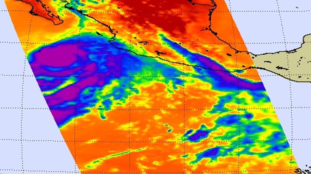
NASA’s Aqua satellite passed over Dolores on July 14 at 20:20 UTC (4:20 p.m. EDT/1:20 p.m. PDT) and the MODIS instrument aboard gathered data that provided a visible picture of the storm. The image showed that the center of Dolores was well off-shore, but the eastern quadrant of the storm was still over the Mexican state of Jalisco. Bands of thunderstorms in Dolores’ northwestern quadrant were just reaching Socorro Island at the time of the image.
Infrared data from the Atmospheric Infrared Sounder or AIRS instrument that also flies aboard Aqua showed some warming of the convective (thunderstorm) cloud tops within the northern semicircle (hurricanes are made up of hundreds of thunderstorms). When cloud tops appear warmer it means they are lower in the atmosphere and do not have as strong an uplift. In short, it means that the thunderstorms are getting weaker.
At 11 a.m. EDT (1500 UTC) on July 15 the eye of Hurricane Dolores was located near latitude 18.4 North, longitude 110.2 West. That puts the eye about 310 miles (500 km) south of Cabo San Lucas, Mexico. Dolores was moving toward the west-northwest near 6 mph (9 kph), and this general motion is expected to continue through Thursday, July 16. A turn toward the west with some increase in forward speed could occur by Thursday night.
The NHC noted that Dolores’ maximum sustained winds remain near 130 mph (215 kph) because it is in an environment with low vertical wind shear and warm waters. Dolores is a category 4 hurricane on the Saffir-Simpson Hurricane Wind Scale. Some strengthening is forecast during the night time hours on July 14, with weakening expected to begin on July 15 when Dolores runs into cooler waters and a more stable environment.
Rob Gutro
NASA’s Goddard Space Flight Center
July 14, 2015 – Satellites See Hurricane Dolores More Organized

Hurricane Dolores appears more organized in satellite data today, July 14, and the cloud tops are colder, indicating that the storm is strengthening.
On July 14, imagery from NOAA’s GOES-West satellite and NASA’s Aqua satellite showed that Dolores cloud pattern became more organized since yesterday, July 13. The imagery showed a well-developed symmetric central dense overcast. Infrared data from the Atmospheric Infrared Sounder (AIRS) instrument that flies aboard NASA’s Aqua satellite showed cloud top temperatures near -80 degrees Celsius/-112 Fahrenheit.
At 5 a.m. EDT (0900 UTC), the center of Hurricane Dolores was located near latitude 17.3 North, and longitude 107.5 West. That’s about 245 miles (395 km) south-southwest of Cabo Corrientes, Mexico. There are no coastal watches or warnings in effect.
NOAA’s National Hurricane Center (NHC) reported that Dolores was moving toward the west near 6 mph (9 kph) and a turn toward the west-northwest is expected later today, July 14. The storm is expected to move in a west-northwesterly direction through July 15. Maximum sustained winds have increased to near 80 mph (130 kph) with higher gusts. The estimated minimum central pressure is 984 millibars.
The NHC noted that as Dolores continues to pull away from the coast, additional rainfall amounts of up to an inch are possible along the southwestern coast of Mexico in the states of Colima and Jalisco. Dolores will continue generating rough surf along the southwestern coast of Mexico, and the rough surf is expected to affect the southern coast of the Baja California Peninsula later today.
The NHC expects Dolores to strengthen over the next two days and become major hurricane on July 15.
Rob Gutro
NASA’s Goddard Space Flight Center
July 13, 2015 – NASA Sees Tropical Storm Dolores Affecting Southwestern Mexico
Tropical Storm Dolores formed close to the southwestern coast of Mexico and has lingered there for a couple of days. NASA’s Terra satellite captured an image of the storm riding the coast.
On July 13, a Tropical Storm Watch is in effect for Lazaro Cardenas to Cabo Corrientes, Mexico.
When NASA’s Terra satellite passed over Tropical Storm Dolores on July 12 at 17:25 UTC (3:25 p.m. EDT), the MODIS instrument captured a visible-light image that showed the storm’s northeastern quadrant over southwestern Mexico. The bulk of thunderstorms associated with Dolores were east of center,
At 700 AM CDT (1200 UTC), the center of Tropical Storm Dolores was located near latitude 16.7 North, longitude 105.3 West. That puts the center of Dolores about 175 miles (275 km) south-southwest of Manzanillo, Mexico.
Dolores is moving toward the west-northwest near 12 mph (19 km/h), and this motion with a decrease in forward speed is expected through Wednesday. On the forecast track, Dolores will gradually move away from the southwestern coast of Mexico today. Maximum sustained winds are near 65 mph (100 kph) with higher gusts.
Dolores’ outer rain bands are expected to produce total rain accumulations of 2 to 4 inches along the southwestern coast of Mexico from the state of Oaxaca to Nayarit. Isolated maximum amounts of 7 inches are possible. In addition, Dolores is causing rough surf conditions that are affecting the southern and southwestern coasts of Mexico and the Baja California peninsula and will affect those areas over the next few days.
For updates on Dolores, visit: www.nhc.noaa.gov
Rob Gutro
NASA’s Goddard Space Flight Center