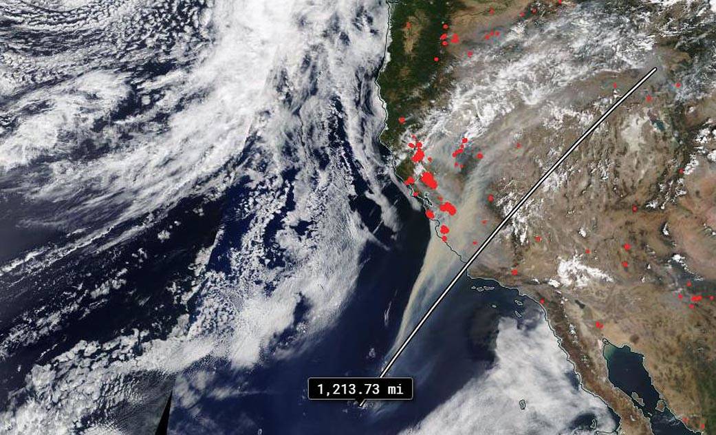
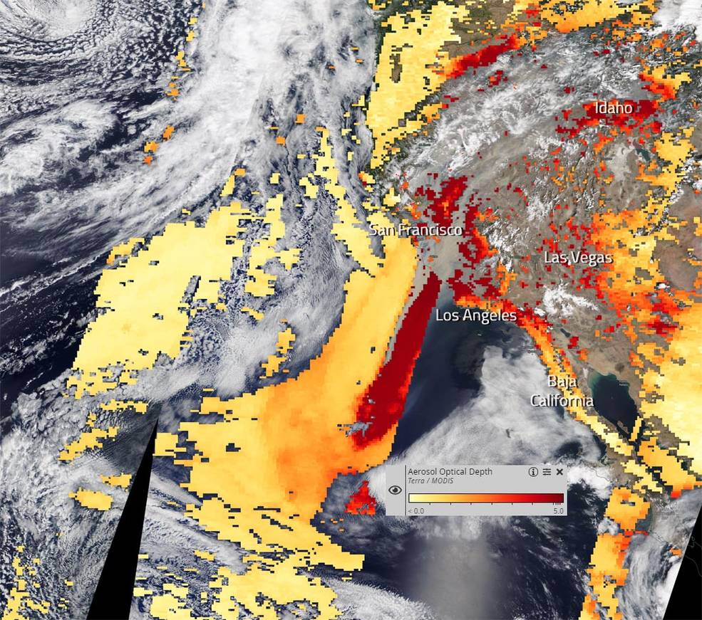
NASA’s Terra satellite was able to capture the huge swath of smoke that has been generated by the California wildfires and dispersed by the winds surrounding those fires on August 20, 2020. The NASA Worldview website has an application that can measure distances within the app and measuring this smoke trail showed the trail’s northeast to southwest trail is approximately 1,214 miles long. The smoke has moved as far north and east as Pocatello, Idaho and as far west and south as mid-Baja California, Mexico. Although the smoke did not go into Baja California it has remained offshore over the Pacific Ocean.
Fire is devastating, and the effects of smoke on humans can also be devastating. The smoke released by any type of fire (forest, brush, crop, structure, tires, waste or wood burning) is a mixture of particles and chemicals produced by incomplete burning of carbon-containing materials. All smoke contains carbon monoxide, carbon dioxide and particulate matter (PM or soot). Smoke can contain many different chemicals, including aldehydes, acid gases, sulfur dioxide, nitrogen oxides, polycyclic aromatic hydrocarbons (PAHs), benzene, toluene, styrene, metals and dioxins. The type and amount of particles and chemicals in smoke varies depending on what is burning, how much oxygen is available, and the burn temperature. Exposure to high levels of smoke should be avoided. Individuals are advised to limit their physical exertion if exposure to high levels of smoke cannot be avoided. Individuals with cardiovascular or respiratory conditions (e.g., asthma), fetuses, infants, young children, and the elderly may be more vulnerable to the health effects of smoke exposure. This information from the Airnow.gov and the CA Dept. of Public Health websites.
From the Worldview site: “Aerosol Optical Depth (AOD) (or Aerosol Optical Thickness) indicates the level at which particles in the air (aerosols) prevent light from traveling through the atmosphere. Aerosols scatter and absorb incoming sunlight, which reduces visibility. From an observer on the ground, an AOD of less than 0.1 is “clean” (lightest yellow) – characteristic of clear blue sky, bright sun and maximum visibility. As AOD increases to 0.5, 1.0, and greater than 3.0, aerosols become so dense that sun is obscured (ranging from yellow to dark red on the scale). Sources of aerosols include pollution from factories, smoke from fires, dust from dust storms, sea salt, and volcanic ash and smog. Aerosols compromise human health when inhaled by people, particularly those with asthma or other respiratory illnesses. Aerosols also have an effect on the weather and climate by cooling or warming the Earth, helping or preventing clouds from forming. Since aerosols are difficult to identify when they occur over different types of land surfaces and ocean surfaces, Worldview provides several different types of imagery layers to assist in the identification.”
In this image there are many areas that are completely obscured by smoke including Los Angeles, Las Vegas, parts of San Francisco and into Idaho, following along the trail of smoke from the fires and out into the Pacific Ocean.
NASA’s Earth Observing System Data and Information System (EOSDIS) Worldview application provides the capability to interactively browse over 700 global, full-resolution satellite imagery layers and then download the underlying data. Many of the available imagery layers are updated within three hours of observation, essentially showing the entire Earth as it looks “right now.” Actively burning fires, detected by thermal bands, are shown as red points. Image Courtesy: NASA Worldview, Earth Observing System Data and Information System (EOSDIS). Caption: Lynn Jenner with information from NASA Worldview.

