Two huge fires in Greece have surrounded Athens and caused havoc in two separate areas outside the capital city. The worst fires to hit Greece in at least a decade have left a deadly trail in their wake. News reports (AP) are stating that at least 74 people have died in the wildfires that swept through the area of Mati which is 18 miles east of Athens. The fires were so quick and devastating that the residents of the area where the fires raged had no time to escape. Gale-force winds contributed to the quick spread of the blaze. Spain, Turkey, Israel, and Italy have all volunteered to help Greece fight the fires. The other large fire raging is 35 miles west of Athens in the Kineta region. In that case, strong winds also pushed the flames along into walls of fire four miles wide. Officials estimate that dozens of houses were also consumed in that blaze.
Almost 50 brush and forest fires broke out across Greece on July 23 and 24, with most of them quickly extinguished according to the local fire department but ten were still burning on July 24, including blazes in Corinth, Crete and in central and northern Greece. Conditions in the area contributed to the size and swift movement of the fire. A dry winter followed by a summer heatwave portends the possibility of a full-blown wildfire outbreak. Coupled with high winds the conditions brought destruction to two areas around Greece.
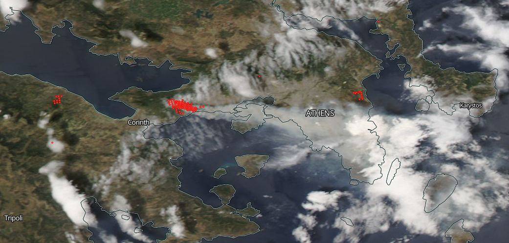
This satellite image was captured on July 24, 2018. Actively burning areas (hot spots) are outlined in red. Each hot spot is an area where the thermal detectors recognized temperatures higher than background. When accompanied by plumes of smoke, as in this image which shows huge clouds of grey-brown smoke belching from the Kineta blaze, such hot spots are diagnostic for fire. NASA image courtesy of the NASA/Goddard Space Flight Center Earth Science Data and Information System (ESDIS) project. Caption by Lynn Jenner with information from the AP.


