Fires are active all around the state of Arizona. Some of have been burning for weeks and others are relatively new. All are dangerous and a cause for concern in the embattled state.
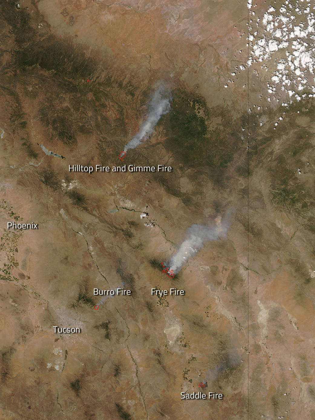
The Hilltop and Gimme fires are located 25 miles north of the town of San Carlos and are currently burning on the San Carlos Apache Reservation near Hilltop Ranch. The fire is threatening commercial ponderosa pine, cultural and natural resources, recreation areas, watershed and wildlife habitat. The Hilltop fire is 8,652 acres and is 5% contained. This fire began as a lightning strike on June 25, 2017. The Gimme Fire is an estimated 432 acres and was also started by a lightning strike on June 25. The perimeter on this fire is completely lined and the fire is in monitor status. Conditions continue to be hot and dry, with slightly less breeze predicted for July 3.
The Burro fire was reported the morning of June 30 and the cause of the fire is under investigation. The fire is located is in the foothills of Redington Pass near Burro Tank. It is burning in tall grass and brush with a moderate to high rate of spread. At present the fire is 14,000 acres. Current weather conditions have temperatures pushing 105+ and low relative humidity in the single digits, both of which promote fire growth.
The Frye Fire was ignited almost a month ago on June 7 with a lightning strike. The fire has been growing ever since and is now 45,154 acres and is 45% contained. Over 670 personnel have been assigned to fighting this fire. Weather conditions in the near term have dry air remaining in place at the surface, setting up the potential for gusty outflow winds and dry lightning. However the overall trend this week will be towards increased moisture as the monsoonal flow becomes established by later this week.
The Saddle Fire is a wildfire which began on June 24. It is currently 5,113 acres and is 90% contained. Fifty persons are attached to this fire. The fire is burning on the Douglas District of the Coronado National Forest, and on Arizona State land near Packsaddle Mountain. Weather conditions portend that dry and hot weather will prevail through Saturday with gusty afternoon winds each day mainly out of the southwest. This does not help firefighting efforts.
NASA’s Aqua satellite collected this natural-color image with the Moderate Resolution Imaging Spectroradiometer, MODIS, instrument on June 05, 2013. Actively burning areas, detected by MODIS’s thermal bands, are outlined in red. Each hot spot, which appears as a red mark, is an area where the thermal detectors on the MODIS instrument recognized temperatures higher than background. When accompanied by plumes of smoke, as in this image, such hot spots are diagnostic for fire.
NASA image courtesy Jeff Schmaltz LANCE/EOSDIS MODIS Rapid Response Team, GSFC. Caption by Lynn Jenner with information from Inciweb.


