


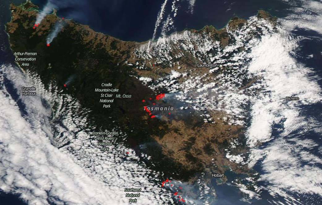
According to the Tasmania Fire Service: “there are four main fires across the state which remain a concern, with fire agencies continuing to strengthen fire containment lines to protect communities, infrastructure and the environment. A total of 19 fires are currently actively burning, with a total burned area of 194,000 hectares (479,384 acres) to date.
The four main fires of concern are:
- Brittons Link, Britons Swamp
- Great Pine Tier, Central Plateau
- Gell River, Southwest
- Riveaux Road, Southwest
The Great Pine Tier Fire broke out yesterday and took a significant run of 8kms (close to 5 miles) to the north of Liawenee, across to Reynolds Neck, where properties were defended by firefighters and the community. The Brittons Swamp fire in North West Tasmania has posed some challenges today with gusty winds from the south. Communities to the north need to be mindful of potential spotting from this fire. This includes areas south of Scotchtown, Christmas Hills and Brittons Swamp. Crews are also continuing to strengthen containment lines on the Gell River and Riveaux Road fires today. Detailed impact assessments are underway state-wide, although assessments have been hampered by smoke and dangerous trees. The Tasmania Fire Service can confirm four houses have been destroyed in the Riveaux Road fire, although further assessments are continuing in the area.
More than 755 personnel have been working on the fires today, including 159 personnel from interstate and New Zealand.”
NASA’s Earth Observing System Data and Information System (EOSDIS) Worldview application provides the capability to interactively browse over 700 global, full-resolution satellite imagery layers and then download the underlying data. Many of the available imagery layers are updated within three hours of observation, essentially showing the entire Earth as it looks “right now. This satellite image was collected on Feb. 04, 2019. Actively burning fires, detected by thermal bands, are shown as red points. Image Courtesy: NASA Worldview, Earth Observing System Data and Information System (EOSDIS). The satellite that took the image was NASA’s Suomi NPP satellite using the VIIRS (Visible Infrared Imaging Radiometer Suite) instrument. Caption: Lynn Jenner