
| Journal Home Page | Apollo 15 Journal |

| Journal Home Page | Apollo 15 Journal |
These feature names occur informally in the Apollo 15 transcripts but do not appear on any mission maps or diagrams that have come to my attention.
123:51:53 Irwin: And, you know, the terrain, looking from the east (means 'to the east'), is just a general rise to the east. It looks like, oh, 2 or 3 percent. Notice that, Dave?123:52:06 Scott: Yeah, up to...
123:52:07 Irwin: Right to the base of the Apennines.
123:52:10 Scott: Yeah.
123:52:1 Irwin: And it's a gradual...
123:52:11 Scott: Right up to the Swann Range there.
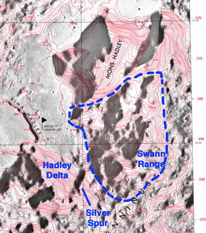
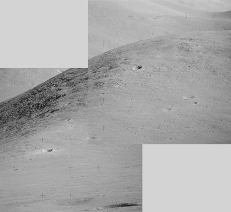
144:50:48 Scott: Okay, Joe, I got the 500 pictures. And I took, first, Mount Hadley; two horizontal strips up at the top where there are some outcrops, and probably the only two craters that I can see on the side of any sizable size. And then a vertical strip through one of the outcrops, and a vertical strip through another outcrop, and then two craters that are in, I guess, what we'd call the forward, leading edge of Swann Mountain over there, which are quite prominent craters. And then I swung over to a bright fresh one that we see, oh, to the northwest, way out. And then I turned back around to Hadley Delta and shot upslope at Hadley Delta, and picked up the debris that seems to be exposed up on the top of Hadley Delta. And now the frames say 120.
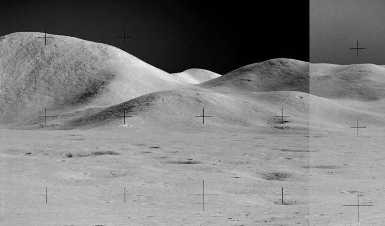
166:32:32 Irwin: We're looking directly east now as we head back to the LM...Did you put your visor down?Because Station 10 is near the rille rim and, therefore, is below the level of the mare surface, Jim's Station 10 pan doesn' t show the base of the mountains to the east. However, Dave's Station 9 pan is a good subsitute, having been taken on the mare surface only about 400m ESE of Station 10 and only about 90 minutes earlier.166:32:38 Scott: Haven't yet, but I think I just might.
166:32:40 Irwin: Boy, that Sun is really fierce. (Pause)
[The Sun's azimuth and elevation are about 110 and 39 degrees, respectively. The bearing to the LM is 093, which is almost directly east.]166:32:49 Irwin: And I can see, as I look to the east, several places up the slope [of] Big Rock Mountain where there're outcrops exposed.166:33:04 Allen: Roger, Jim. Copy...
166:33:05 Irwin: One about a quarter of the way up directly east from us...That was Big Rock Mountain.
[Jim never finishes his comment about the outcrop 'about a quarter of the way up'.]166:33:06 Allen: And the name of the mountain again, please.166:33:12 Irwin: That was Big Rock Mountain.
166:33:14 Scott: You know, Joe. Big Rock-o Candy Mountain.
[Here, Dave is making sure that Rocco Petrone understands that the mountain is being named for him. He is also referring to the song Big Rock Candy Mountain that was first recorded in 1928 by Harry McClintock but was best known from a 1949 Burl Ives recording.]166:33:18 Allen: Roger; we copy. (Pause) And do we have a big smile here in the MOCR.166:33:30 Irwin: (Laughs)
[Scott - "I think we decided, at some point, that we would call that 'Big Rock Mountain', after Rocco Petrone. He picked the landing site. He made the decision."]


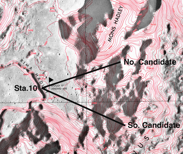
The first candidate is to the right of the Sun in both pans and has summit outcrops that are prominent even in the photographs.
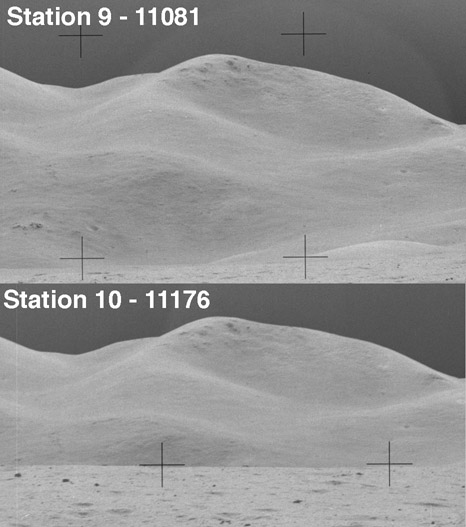

When Dave got back to the LM, he took the time at 167:10:16 to take a number of 500mm shots to the east, including a portrait of the northern candidate. Thirty five years after the fact, it is impossible to know with certainty why Dave took these photographs and none of the southern candidate. The one clue we have is the following exchange Dave and Jim had late in the drive back to the LM:
166:38:03 Scott: Boy, look at the few big boulders up there. Yeah, that's pretty neat.A detail may show the boulders discussed here. They are near the summit of the northern candidate. This exchange and Jim's earlier description lead me to believe that the northern candidate is Big Rock Mountain.166:38:07 Irwin: Up on the slope of...
166:38:08 Scott: Yeah.
166:38:09 Irwin: It's appropriately named, don't you think?
166:38:11 Scott: Yes, it is. (Pause) It's the only one around here.
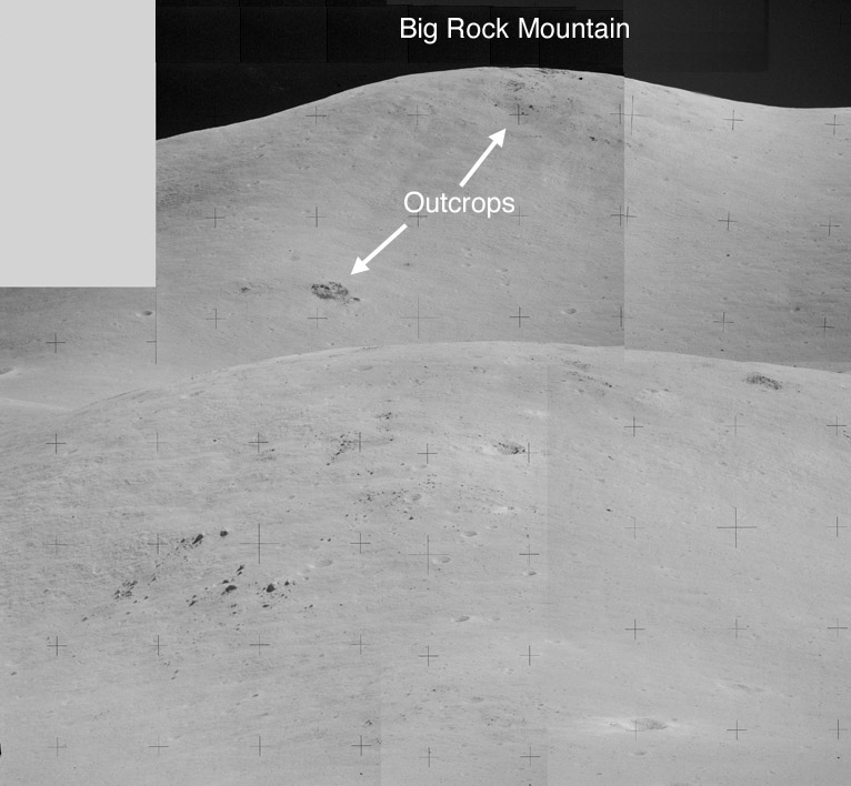
However, based on the clear evidence of Jim's description during the drive back from Station 10, I believe that Jim was applying the name Big Rock Mountain to one of the summits in the Swann Range. Certainly, Jim was not describing Mt. Hadley. In addition, I am not aware of any instances of the Apollo crews giving new names to previously named lunar features. Because of a conflict with the International Astronomical Union over names chosen by the crews for previously-unnamed features that raged throughout the Apollo years, I doubt that the crew would have seriously considered weakening their asserted naming rights by proposing to rename so prominent a feature as Mt. Hadley. Based on the evidence in hand, I believe the northern candidate more closely matches Jim's description than does the southern candidate.
106:57:23 Irwin: When you finish with the 500, Dave, I have the other camera.[The third camera has a 60-mm lens and a color magazine.]106:57:25 Scott: Okay. Try not to hit my foot there. (Long Pause) Looking back into the Sun is almost useless, Joe. Really blots everything out.[Dave has turned to the east to take a 500-mm mini-pan of the base of Mt. Hadley.]106:57:57 Allen: Rog, Dave. Any sign of the big mountain back there?106:58:02 Scott: Yeah. You can see Big Rock Mountain back there!
106:58:07 Allen: Roger. Copy Big Rock Mountain. (Long Pause)
[Note that, at 106:57:57, Joe was not passing on a question from the Backroom but, rather, was reminding Dave to mention Petrone's mountain.]Although there are no explicit clues as to the identity of Big Rock Mountain in this exchange, the eastern portion of Dave's B & W pan shows the scene.Eastern portion of Dave's B & W SEVA pan
Dave took the pan at 106:54, which corresponds to 0028 GMT/UTC on 31 July 1971. The solar azimuth and elevation were 96.4 and 13.4 degrees, respectively.
with Mt. Hadley on the left and Silver Spur on the far right
Journal Home Page Apollo 15 Journal