Warmer than average sea surface temperatures in the tropical North Atlantic Ocean so far in 2020 have set the stage for an active hurricane season and elevated the risk of fires in the southern Amazon, according to scientists at NASA and the University of California, Irvine.
Variations in ocean sea surface temperatures alter weather patterns around the world. In the case of the Atlantic Ocean, warmer surface waters near the equator draw moisture northward and away from the southern Amazon, favoring the development of hurricanes. As a result, the southern Amazon landscape becomes dry and flammable, making human-set fires used for agriculture and land clearing more prone to growing out of control and spreading.
The National Oceanographic and Atmospheric Administration is responsible for operational hurricane forecasting and monitoring in the United States. NASA’s role as a research agency is to develop new types of observational capabilities and analytical tools to learn about the fundamental processes that drive hurricanes and the connections between hurricanes and regional rainfall variability to incorporate data that capture those mechanisms in forecasts.
“The fire season forecast is consistent with what we saw in 2005 and 2010, when warm Atlantic sea surface temperatures spawned a series of severe hurricanes and triggered record droughts across the southern Amazon that culminated in widespread Amazon forest fires,” said Doug Morton, chief of the Biospheric Sciences Laboratory at NASA’s Goddard Space Flight Center in Greenbelt, Maryland.
More on the Amazon Fire season.
Morton is co-creator of an Amazon fire season forecast. Now in its ninth year, the forecast analyzes the relationship between climate conditions and active fire detections from NASA satellite instruments, such as the Moderate Resolution Imaging Spectroradiometer on Terra and Aqua, to predict fire season severity.
“Our seasonal fire forecast provides an early indication of fire risk to guide preparations across the region,” Morton said, noting that the forecast is most accurate three months before the peak of burning in the southern Amazon in September. “Now, satellite-based estimates of active fires and rainfall will be the best guide to how the 2020 fire season unfolds.”
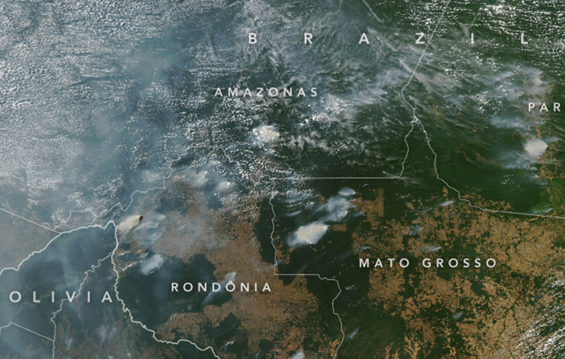
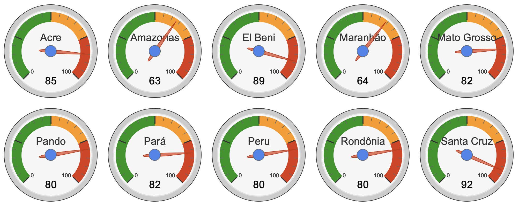
This Amazon fire season is one to watch with yet extra caution, Morton said. The Brazilian states with the highest projected fire risk this season — Pará, Mato Grosso, and Rondônia — were among the regions with the most deforestation fire activity last year, which itself saw the largest number of active fire detections in the Amazon basin since 2010.
In addition, the COVID-19 global pandemic may further increase the logistical difficulties in responding to fire emergencies in remote regions of the Amazon, Morton said, as restricted travel, teleworking environments, and higher priorities for both budget and personnel mean that firefighting may be more challenging.
“You have a perfect storm: drought, the recent increase in deforestation, and new difficulties for firefighting,” Morton said. “2020 is set up to be a dangerous year for fires in the Amazon.” With the help of the new SERVIR-Amazonia hub, the forecast has already been distributed to agency leads in Brazil and Peru to communicate the potential for drought conditions to amplify fire risk this year.
The long-term outlook for the Amazon fire season is dependent on both climate and human fire ignitions, said Yang Chen, Earth scientist at the University of California, Irvine, and co-creator of the Amazon fire season forecast.
“Changes in human fire use, specifically deforestation, add more year-to-year variability in Amazon fires,” Chen said. “In addition, climate change is likely to make the entire region drier and more flammable – conditions that would allow fires for deforestation or agricultural use to spread into standing Amazon forests.”
Meanwhile, the U.S. Atlantic hurricane season has already shown signs of increased activity, with five named storms already in the books early in the season, Morton said. Nevertheless, a complex set of conditions influence the formation of tropical storms. For instance, in June, a large Saharan dust plume wafted across the Atlantic, temporarily suppressing storm formation. These circumstances highlight both the interconnectedness and complexity of the Earth system, as rapid changes in atmospheric conditions or sea surface temperatures will influence rainfall patterns in 2020 and the potential for synchronized impacts from hurricanes and fires.
Banner Image:
On August 11, 2019, the Moderate Resolution Imaging Spectroradiometer (MODIS) on NASA’s Aqua satellite captured these images of several fires burning in the states of Rondônia, Amazonas, Pará, and Mato Grosso. This year’s drought combined with the recent uptick in deforestation make these states particularly vulnerable this fire season to fires that can grow out of control and spread. Credits: NASA Earth Observatory images by Lauren Dauphin, using MODIS data from NASA EOSDIS/LANCE and GIBS/Worldview and VIIRS data from NASA EOSDIS/LANCE and GIBS/Worldview, and the Suomi National Polar-orbiting Partnership.

