Rina Now a Large Post-Tropical Storm in North Central Atlantic
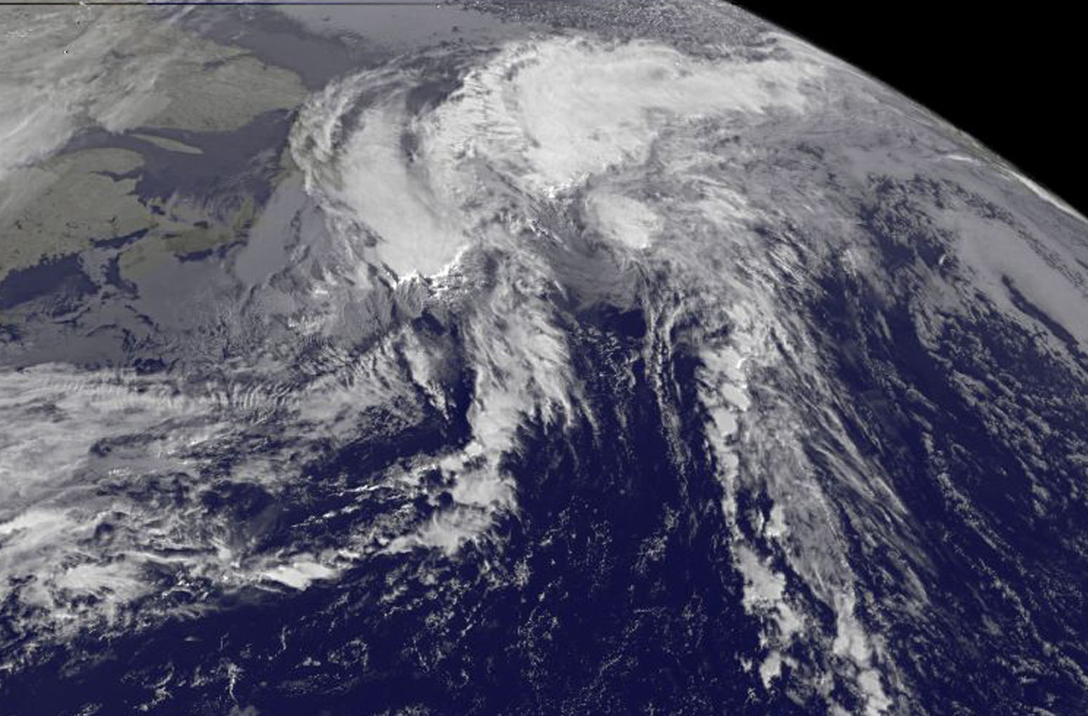
Tropical Storm Rina has lost its tropical characteristics and has become post-tropical as it continues to move through the Central North Atlantic Ocean. NOAA’s GOES East satellite provided a visible image of the storm.
Imagery from NOAA’s GOES East satellite, other satellite images and surface data indicate that Rina has become a post-tropical cyclone. GOES East provided a visible image at 7:45 a.m. EST on Nov. 9 that showed the system was embedded within low stratus clouds. The National Hurricane Center noted that cool air temperatures around 45 degrees Fahrenheit were about a degree to the northwest of the center. The GOES East image shows that Rina is a large post-tropical storm. Tropical-storm-force winds extend outward up to 275 miles (445 km), mainly to the east of the center.
At 11 a.m. AST (10 a.m. EDT/1500 UTC) on Nov. 9, 2017 the National Hurricane Center issued the last public advisory on the system. At that time the center of Post-Tropical Cyclone Rina was located near 47.0 degrees north latitude and 45.5 degrees west longitude. That’s about 360 miles (580 km) east of Cape Race, Newfoundland, Canada or 1,480 miles (2,385 km) southwest of Reykjavik, Iceland. The estimated minimum central pressure is 998 millibars.
The post-tropical cyclone was racing toward the northeast near 40 mph (65 kph) and a faster northeastward or east-northeastward motion is expected until dissipation on Friday, Nov. 10. Maximum sustained winds were near 45 mph (75 kph) with higher gusts. Little change in strength is forecast before the low dissipates.
The National Hurricane Center noted “despite being over water temperatures around 9 degrees Celsius instability aloft is still producing some elevated deep convection well northeast of the center, though this is not indicative of tropical cyclone status.”
The cyclone is expected to move rapidly to the northeast and east-northeast over the next day before becoming elongated and dissipating west of Ireland.
By Rob Gutro
NASA’s Goddard Space Flight Center
Nov. 08, 2017 – NASA Eyes a Comma-Shaped Tropical Storm Rina
The NASA-NOAA Suomi NPP satellite passed over Tropical Storm Rina and found that the storm has taken on a tight comma-cloud appearance.
The Visible Infrared Imaging Radiometer Suite or VIIRS instrument aboard the Suomi NPP satellite captured a visible image of Rina on Nov. 7 at 10:48 a.m. EST (1548 UTC). The VIIRS image revealed that Rina had developed the comma shape and a bulk of the clouds were east of the center.
The National Hurricane Center (NHC) noted that the tight comma-cloud shape is more indicative of a sub-tropical cyclone than a tropical system. On Nov. 8, NHC noted “Although an eye-like feature has recently developed, it appears to be tilted about 20-30 nautical miles to the north of the low-level center.”
At 4 a.m. EST (5 a.m. AST/900 UTC) on Nov. 8 the center of Tropical Storm Rina was located near 37.1 degrees north latitude and 48.4 degrees west longitude. That’s about 705 miles (1,135 km south-southeast of Cape Race, Newfoundland, Canada. Rina was moving toward the north near 20 mph (31 kph). NHC expects Rina to turn toward north-northeast followed by a rapid northeastward motion on Thursday, Nov. 9. The estimated minimum central pressure is 997 millibars.
Maximum sustained winds have increased near 60 mph (95 kph) with higher gusts. Little change in strength is forecast before weakening begins on Thursday.
Rina is expected to become a post-tropical cyclone by tonight or early Thursday morning.
For updated forecasts, visit: www.nhc.noaa.gov
By Rob Gutro
NASA’s Goddard Space Flight Center
Nov. 07, 2017 – NASA Tracking Atlantic’s Tropical Storm Rina
NASA-NOAA’s Suomi NPP satellite has been providing forecasters with imagery of Tropical Storm Rina as it moves north through the Central Atlantic Ocean.
Tropical Depression 19 strengthened into a tropical storm and was renamed Rina at 10 p.m. EST on Nov. 6.
On Nov. 6 the Visible Infrared Imaging Radiometer Suite (VIIRS) instrument aboard NASA-NOAA’s Suomi NPP satellite captured a visible image of the storm as it was strengthening to tropical storm status. The image showed that Rina’s overall cloud pattern increased in coverage in the eastern quadrant of the storm. There also appeared to be with a little more deep convection having developed near the low-level center of circulation. The image was created at NASA’s Goddard Space Flight Center in Greenbelt, Md.
By 4 a.m. EST (5 a.m. AST) on Tuesday, Nov. 7 the center of Tropical Storm Rina was located near 31.4 degrees north latitude and 49.8 degrees west longitude. That’s about 1,370 miles (2,200 km) west-southwest of the Azores islands. Rina was moving toward the north near 12 mph (19 kph). This general motion accompanied by an increase in forward speed is expected through today. A turn toward north-northeast is forecast to occur by Wednesday night, Nov. 8.
Maximum sustained winds are near 40 mph (65 kph) with higher gusts. Some strengthening is forecast during the next 48 hours. The estimated minimum central pressure of 1009 millibars is based on recent reports from a nearby buoy.
NHC forecaster Stewart noted “the cyclone should continue to accelerate toward the north today and then toward the north-northeast on Wednesday. By 48 hours, Rina is expected to get caught up in the mid-latitude westerlies and accelerate even more toward the northeast over the cold waters of the north Atlantic.
For updated forecasts on Rina, visit: www.nhc.noaa.gov
By Rob Gutro
NASA’s Goddard Space Flight Center
Nov. 06, 2017 – NASA Sees Late Season Atlantic Tropical Depression Form
NASA’s Terra satellite passed over Tropical Depression Nineteen shortly after it formed in the Central Atlantic Ocean on Nov. 6. A visible image from Terra showed the storm formed despite being under wind shear conditions.
The National Hurricane Center in Miami noted that the depression is no threat to land and is expected to become a tropical storm.
The Moderate Resolution Imaging Spectroradiometer or MODIS instrument aboard NASA’s Terra satellite provided a visible image of Tropical Depression 19 early on Nov. 6. The image showed the bulk of clouds and thunderstorms in the eastern and southern quadrants of the storm. The National Hurricane Center noted “The depression has a sheared appearance with the low-level center exposed to the west of the mid-level center and the convective bands.”
At 11 a.m. AST (10 a.m. EST/1500 UTC) the center of Tropical Depression Nineteen was located near 29.5 degrees north latitude and 50.4 degrees west longitude. That’s about 1,460 miles (2,350 km) west southwest of the Azores Islands. The depression was moving toward the north-northeast near 3 mph (6 kph). A significantly faster north to north-northeast motion is expected during the next couple of days.
Maximum sustained winds are near 35 mph (55 kph) with higher gusts. The estimated minimum central pressure is 1013 millibars. .
Slow strengthening is expected during the next 48 hours, and the depression could become a tropical storm later in the day on Monday, November 6, 2017. Hurricane Season in the Atlantic ends officially on Nov. 30.
For updated forecasts on Tropical Depression 19, visit: www.nhc.noaa.gov
By Rob Gutro
NASA’s Goddard Space Flight Center

