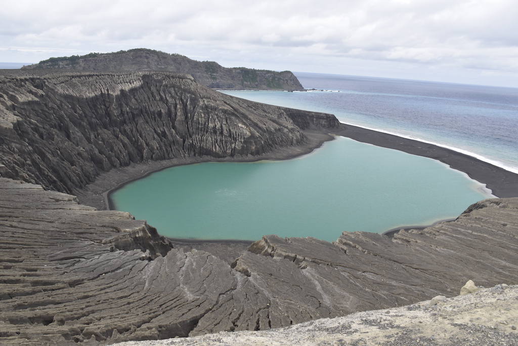
In late December 2014, a submarine volcano in the South Pacific Kingdom of Tonga erupted, sending a violent stream of steam, ash and rock into the air. The ash plumes rose as high as 30,000 feet (9 kilometers) into the sky, diverting flights. When the ash finally settled in January 2015, a newborn island with a 400-foot (120-meter) summit nestled between two older islands – visible to satellites in space.
The newly formed Tongan island, unofficially known as Hunga Tonga-Hunga Ha’apai after its neighbors, was initially projected to last a few months. Now it has a 6- to 30-year lease on life, according to a new NASA study.
Hunga Tonga-Hunga Ha’apai is the first island of this type to erupt and persist in the modern satellite era, it gives scientists an unprecedented view from space of its early life and evolution. The new study offers insight into its longevity and the erosion that shapes new islands. Understanding these processes could also provide insights into similar features in other parts of the solar system, including Mars.
Credits: NASA’s Goddard Space Flight Center/Lauren Ward
“Volcanic islands are some of the simplest landforms to make,” said first author Jim Garvin, chief scientist of NASA’s Goddard Space Flight Center in Greenbelt, Maryland. “Our interest is to calculate how much the 3D landscape changes over time, particularly its volume, which has only been measured a few times at other such islands. It’s the first step to understand erosion rates and processes and to decipher why it has persisted longer than most people expected.”
The Tongan island is the third “surtseyan” volcanic island in the last 150 years to emerge and persist for more than a few months. Surtsey is an island that began forming during a similar kind of explosive, marine eruption off the coast of Iceland in 1963.
From the Tongan island’s beginning, it was tracked by monthly, high-resolution satellite observations, both with optical sensors and radar, which sees through clouds. Alerted to the volcanic eruption by NASA’s Rapid Response program for the Moderate Resolution Imaging Spectroradiometer (MODIS) instruments, Garvin and his colleagues directed satellites to observe the island as soon as the eruption ended. Using this imagery, the research team made three-dimensional maps of the island’s topography and studied its changing coastlines and volume above sea level.
The team has calculated two potential scenarios affecting its lifetime. The first is a case of accelerated erosion by wave abrasion, which would destabilize the tuff cone in six to seven years, leaving only a land-bridge between the two adjacent older islands. The second scenario presumes a slower erosion rate, which leaves the tuff cone intact for about 25-30 years.
The different scenarios are due to uncertainty in the estimate of the initial volume of the island tuff cone immediately after the eruption and before the first stereo satellite images were acquired at three months. They also reflect the different rates of erosion witnessed in the first six months (accelerated) versus later (more moderate). Their analysis was presented at the American Geophysical Union Fall Meeting in New Orleans on Dec. 11.
The most dramatic changes to the island occurred in its first six months. Initially, the new island was relatively oval and attached to its neighboring island to the west. However, by April analysis of satellite imagery found that its shape had changed dramatically.
“Those cliffs of volcanic ash are pretty unstable,” said remote sensing specialist and NASA Goddard co-author Dan Slayback of the receding cliffs on the southern side of the island. Wave action then redistributed the eroded sediment to form a land bridge to the existing island to the east, he said.
In May, the southeastern rim of the interior crater wall was washed over by the Pacific Ocean, opening the crater lake to the ocean. At this point both Garvin and Slayback thought this might be the end of the island. But by June, satellite imagery showed that a sandbar had formed, closing off the crater. While the island continued to evolve, it was more stable by late 2016.
The new island is perched on the north rim of a caldera on top of an underwater volcano that stands nearly 4,600 feet (1,400 meters) above the surrounding the sea floor, according to seaborne bathymetry measurements made by geologist and co-author Vicki Ferrini at the Lamont-Doherty Earth Observatory at Columbia University in Palisades, New York.
Underwater, the base of the new volcanic dome that formed the island extends about 0.6 miles (1 kilometer) from the shoreline into the floor of the larger caldera, which is about three miles (five kilometers) across. In the shallowest part of the survey area closest to the southern side of island, the seafloor levels out into a nearly flat shelf, which is likely important in explaining the pattern of redistribution for the eroded material, Ferrini said.
Evidence of past eruptions from other, smaller domes are also apparent around the rim of the caldera, though few break the surface.
Credits: Visualization credit: NASA’s Goddard Space Flight Center/Scientific Visualization Studio/Cindy Starr; Video credit: NASA/Damien Grouille/Cecile Sabau
“There’s a huge amount of material that came out from this eruption, possibly larger than at Surtsey,” said Ferrini. “The other interesting thing is that the two islands that surround this new land mass have some pretty tough substrate, so there’s something happening to help make this solidify and stay in place, chemically.”
The 54-year old Surtsey island near Iceland survived past its first few months because warmed seawater interacted with ash after the eruption, chemically altering the fragile and easily eroded rock into a tougher material. Garvin and Ferrini believe something similar may have occurred with this new island. Their next step is a detailed chemical analysis of rock samples.
The Tongan island may also help researchers understand volcanic features on Mars that look similar.
“Everything we learn about what we see on Mars is based on the experience of interpreting Earth phenomena,” Garvin said. “We think there were eruptions on Mars at a time when there were areas of persistent surface water. We may be able to use this new Tongan island and its evolution as a way of testing whether any of those represented an oceanic environment or ephemeral lake environment.”
Wet environments such as these combined with heat from volcanic processes, he added, may be prime locations to search for evidence of past life.
Download multiple versions of these videos from NASA’s Scientific Visualization Studio.

