Editor’s note: The launch date for NASA’s ICON has been scheduled for Nov. 7, 2018, from Cape Canaveral Air Force Station in Florida. The original story as issued on Oct. 18, 2017, appears below.
On Dec. 8, 2017 [Ed. note: the launch date has been scheduled for Nov. 7, 2018], NASA launches the Ionospheric Connection Explorer, or ICON, a low-Earth orbiting satellite that will give us new information about how Earth’s atmosphere interacts with near-Earth space — a give-and-take that plays a major role in the safety of our satellites and reliability of communications signals.
Specifically, ICON investigates the connections between the neutral atmosphere — which extends from here near the surface to far above us, at the edge of space — and the electrically charged part of the atmosphere, called the ionosphere. The particles of the ionosphere carry electrical charge that can disrupt communications signals, cause satellites in low-Earth orbit to become electrically charged, and, in extreme cases, cause power outages on the ground. Positioned on the edge of space and intermingled with the neutral atmosphere, the ionosphere’s response to conditions on Earth and in space is difficult to pin down.
“The conditions in our space environment — space weather — is something we need to be able to forecast,” said Thomas Immel, principal investigator for the ICON mission from the University of California, Berkeley.“It’s difficult to predict conditions in the ionosphere tomorrow based on what we measure today.”
Earth’s interface to space
As one goes higher and higher above Earth’s surface, the atmosphere gradually gets thinner. The effects of these changes can be felt just a few miles above sea level — for instance, climbers on some of the world’s tallest mountains must often use oxygen tanks to breathe. But even higher, about 60 miles above Earth’s surface, the atmosphere becomes so thin that planes can’t fly. This is where space begins.
Even beyond this boundary of space, Earth’s atmosphere continues to extend upward — it just gets thinner and more tenuous the higher you go. This region is above Earth’s ozone layer, so it’s exposed to the full brunt of the Sun’s radiation. The strong ultraviolet radiation breaks down stable, neutral molecules, changing them from something resembling the air we breathe into more reactive forms of gas, like atomic oxygen. These reactive compounds in the neutral upper atmosphere produce a faint, global glow, called airglow.
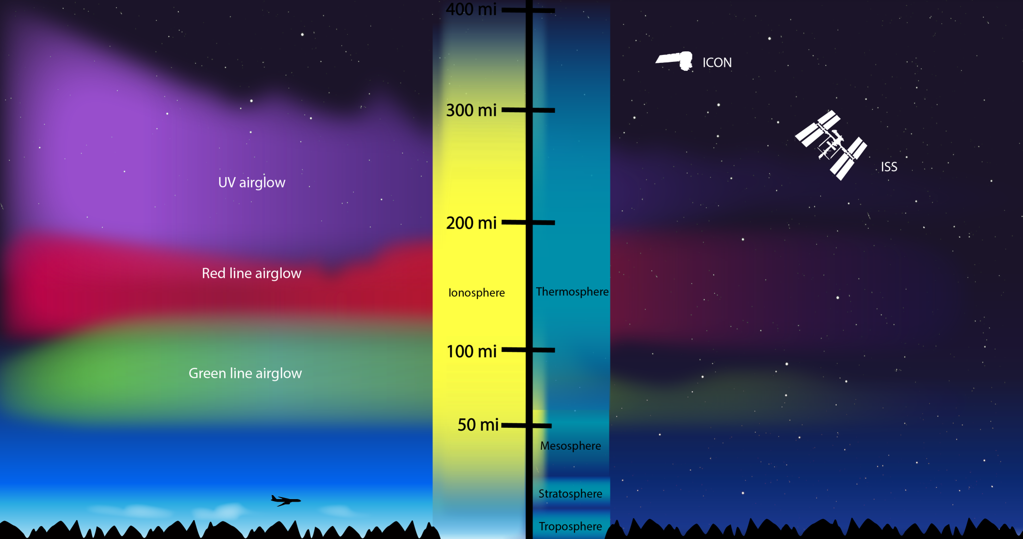
But the sunlight doesn’t stop there. It keeps breaking these atmospheric molecules apart, knocking off electrons, which leaves a sea of charged electrons and ions. This population of electrically charged particles is the ionosphere, and it exists in the same space as the extremely thin neutral upper atmosphere.
This makes our interface to space a unique region, where charged and neutral gases coexist. It is shaped both by weather patterns and winds from Earth below, and shifting electric and magnetic fields and space weather from above.
“ICON aims to understand how Earth’s weather modifies space weather,” said Doug Rowland, mission scientist for ICON at NASA’s Goddard Space Flight Center in Greenbelt, Maryland. “We’re looking at how the weather that we live in — rain, heat, snow, thunderstorms, hurricanes — affects the space environment above us.”
Space weather is often triggered by changes on the Sun, which releases a constant outflow of magnetized material called the solar wind along with less frequent but more intense bursts of solar material, called coronal mass ejections. The magnetic fields embedded in this solar material can deform Earth’s natural magnetic field, creating shifting electric and magnetic fields in near-Earth space. The electrically-charged gas of the ionosphere, called plasma, reacts uniquely to these changing electric and magnetic fields.
Many low-Earth orbiting satellites, including the International Space Station, fly through the ionosphere. It also acts as a conduit for many of our communications signals, such as radio waves and the signals that make GPS systems work. Unpredicted changes in the ionosphere, like ripples and bubbles of dense plasma, can have significant impacts on our technology and communication.
“Short-wave radio waves bounce off the ionosphere, and signals from GPS satellites have to pass through,” said Immel. “The changes in density directly affect communications and navigation.”
Understanding the details of what influences the ionosphere and causes signal disruptions has historically been difficult, in part because of the range of factors that can change the ionosphere. For decades, scientists thought that the ionosphere responded only to the changing conditions in space. New data over the past few decades, however, has proved that assumption wrong, and revealed that there’s still much to learn about the forces that shape the ionosphere.
Credit: NASA’s Goddard Space Flight Center
Download this video in HD formats from NASA’s Goddard Space Flight Center’s Scientific Visualization Studio
“What we discovered, using data from a NASA mission called IMAGE, was that this region of the upper atmosphere and ionosphere was actually responding to effects related to weather systems near Earth’s surface,” said Scott England, ICON project scientist based at Virginia Tech in Blacksburg. IMAGE, short for Imager for Magnetopause-to-Aurora Global Exploration, studied Earth’s magnetosphere from 2000 to 2005. “This was really unexpected at the time, to see a connection. Where the charged particles were, how many there were, how dense the gas was — they were responding to weather patterns near the surface of the Earth.”
Pockets of high or low pressure are produced near Earth’s surface by hurricanes, thunderstorms, or even phenomena as simple as a steady wind over a mountain range. These pressure differences can propagate into the very highest reaches of the upper atmosphere and influence the winds in this region. The exact role that these winds — and by extension, terrestrial weather — play in shaping the ionosphere is an outstanding question, and one that scientists hope ICON will answer.
“We think the winds will be directly related to the electric field measured at the spacecraft, but we don’t know,” said Immel. “No one’s ever made this measurement, so no one knows what we’re going to see.”
Eyes on the ionosphere
ICON explores these connections between the neutral atmosphere and the electrically charged ionosphere with four instruments. Three of these four instruments rely on one of the upper atmosphere’s more spectacular phenomena: airglow.
Airglow is created by a similar process that creates the aurora: gas is excited and emits light. Though auroras are typically confined to extreme northern and southern latitudes, airglow happens constantly across the globe, and it is much fainter. But it’s still bright enough for ICON’s instruments to build up a picture of the density, composition and structure of the ionosphere.
One of these airglow-measuring instruments is MIGHTI, short for Michelson Interferometer for Global High-resolution Thermospheric Imaging. Designed and built by the Naval Research Lab in Washington, D.C., MIGHTI measures the Doppler shift of the glowing gases of the upper atmosphere and ionosphere.
“The Doppler shift is the same process you can hear when you hear a siren on an ambulance: It has a different pitch when the ambulance is coming towards versus moving away from you,” said England. “The same thing is happening with the light from airglow.”
When gas producing airglow moves toward or away from ICON, pushed by winds, the wavelengths are stretched or compressed. Because scientists know what chemical species produce airglow in the upper atmosphere, they know very specifically what wavelength — or color — that light should be. The Doppler-shifted light has an ever-so-slightly different hue that MIGHTI can detect, and from there, scientists can deduce the speed and direction of the winds in this region.

Instruments similar to MIGHTI have flown on space missions before, but with a key difference. Earlier space-based interferometers would use moving parts to change the distance between different reflectors and detectors in order to measure each wavelength of light. But MIGHTI uses a tool called a diffraction grating — similar to a mirror with lines etched in it that reflect light in a certain way — to separate the light it sees into its component wavelengths simultaneously. This means that MIGHTI can measure multiple wavelengths at once, making the instrument more sensitive.
“MIGHTI can measure changes in the wind speed of around 10 miles per hour,” said England. “If you translate that into the actual change in the wavelength, that’s a change of about 1 in 100 million.”
Another airglow instrument, the Far Ultraviolet instrument, uses an advanced de-blurring technique called time-delay integration to send back more information for scientists within the data bandwidth restrictions of the spacecraft.
“We have the bandwidth to send down one snapshot every 12 seconds, but the spacecraft moves about a hundred kilometers in that amount of time, and the structures we want to look at are only a few kilometers wide,” said Rowland. “You would smear all these small-scale structures.”
What the Far Ultraviolet instrumentdoes instead, said Rowland, is take eight snapshots per second — almost a hundred times as much data as ICON can send down — and combine them, with each one shifted appropriately to account for warping and the geometry of the spacecraft. This processing, which all happens on ICON’s onboard computer, creates a single image that can be sent back to Earth within the bandwidth allotted. This combines the advantages of a long exposure by compressing the data, while still maintaining the sharp focus that gives scientists a detailed look at the structures they’re interested in. The wavelengths measured by FUV are produced by certain types of oxygen and nitrogen molecules on Earth’s day side, as well as oxygen ions on Earth’s night side.
ICON’s third airglow instrument, EUV — short for Extreme Ultraviolet instrument — measures shorter wavelengths of light than FUV. Airglow measured by EUV is produced by oxygen ions on Earth’s day side, which make up the lion’s share of Earth’s daytime ionosphere. EUV’s data will reveal details about the structure of the ionosphere during the day — like how far it extends, and where pockets of denser plasma form — that can change the ionosphere’sinteraction with communications signals and satellites.
While ICON’s three airglow instruments measure the temperature, velocity and composition of gases miles away from the spacecraft, a pair of identical in situ instruments characterizes the charged gas around the spacecraft. The two Ion Velocity Meters, or IVMs, make very precise measurements of the angle at which ionized gas enters the instrument, helping scientists understand how this ionized gas around the spacecraft is moving.
In the past, scientists may have had to combine instruments from different spacecraft — sometimes even from different years — to try and make connections between the lower atmosphere, neutral upper atmosphere and ionosphere. But one of ICON’s main advances is the combination of data from its four instruments at the same place and time
“The unique thing is the suite of instruments,” said Ellen Taylor, ICON project systems engineer at UC Berkeley. “ICON has several instruments that have been flown before, but they’re put together into a payload suite to make unique measurements.”
ICON’s orbit is also designed to create a few points during each orbit where the remote sensing instruments look straight down Earth’s magnetic field. That means the spacecraft’s in situ plasma measurements are sometimes directly magnetically connected to the remote measurements of airglow, even though they’re hundreds of miles apart.
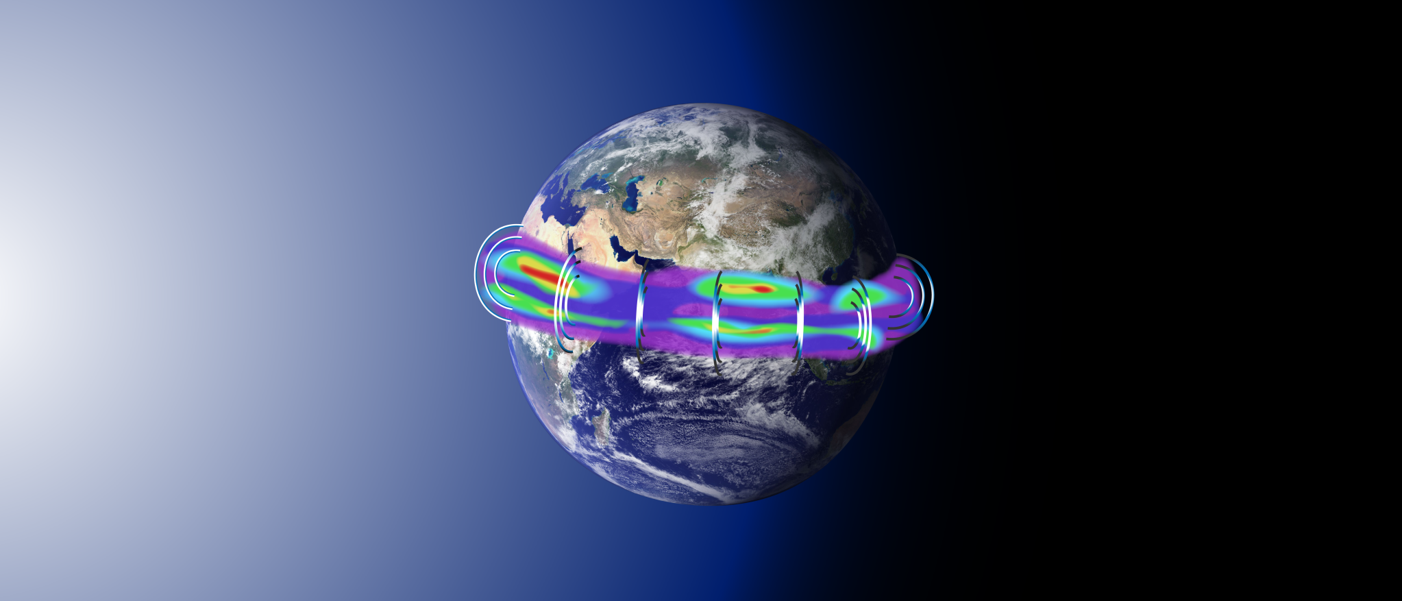
ICON’s data will be complemented by the January 2018 launch of the GOLD instrument, short for Global-scale Observations of the Limb and Disk. Hosted on a commercial satellite in geostationary orbit, GOLD also will observe the ionosphere, but from a vantage point very different from ICON’s: GOLD will see the big picture, while ICON flies through the ionosphere, collecting data from up close.
“To study hurricanes, we might use a weather satellite to track how they’re moving across the ocean, but to get detailed information, we fly a plane through the storm,” said England. The same relationship holds true for ICON and GOLD studying the ionosphere. “GOLD is like the weather satellite, and ICON is like the airplane.”
ICON launches on a Pegasus rocket from Kwajalein Atoll in the Marshall Islands in the Pacific Ocean [Ed. note: ICON now launches from Cape Canaveral Air Force Station in Florida]. Carried underneath the L-1011 airplane out over the ocean, the launch window opens at approximately 3 a.m. local time on Dec. 8 [Ed. note: the launch window opens at approximately 4 a.m. local time on Oct. 26, 2018.]. NASA TV will cover the launch.
After launch, Taylor’s team will be in the mission operations center at UC Berkeley 24/7 for nearly a week to commission the spacecraft. This is followed by another three weeks of instrument commissioning, during which each one of the instruments is prepared to take science data — by powering up, opening sensor doors, ramping up voltage and cooling down detector plates. After instrument and payload commissioning, ICON should be fully online and sending back data by about a month after launch.
ICON is an Explorer-class mission. NASA Goddard manages the Explorer Program for NASA’s Heliophysics Division within the Science Mission Directorate in Washington. UC Berkeley’s Space Sciences Laboratory developed the ICON mission, EUV and FUV, the Naval Research Laboratory in Washington, D.C., developed the MIGHTI instrument, the University of Texas in Dallas developed IVM, and the ICON spacecraft and Pegasus launch vehicle were built by Orbital ATK in Dulles, Virginia.
Related:
By Sarah Frazier
NASA’s Goddard Space Flight Center, Greenbelt, Md.


