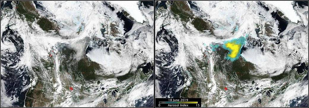
Several wildfires were burning in the province of Alberta, Canada, when NASA-NOAA’s Suomi NPP satellite passed overhead on June 18. Two instruments aboard the satellite provided an analysis of clouds, smoke and aerosols generated by Canadian fires.
Identifying Pyrocumulus Clouds
The fires burning in northern Alberta produced a pair of pyroCb (short for pyrocumulonimbus) events on Sunday, June 16 and Monday, June 17 that lofted significant smoke into the atmosphere. A smaller area of pyrocumulus clouds occurred on June 18, and again on June 19.
The VIIRS or Visible Infrared Imaging Radiometer Suite instrument aboard Suomi NPP provided a visible image that revealed the pyrocumulus clouds. VIIRS is a scanning radiometer that collects visible and infrared imagery and radiometric measurements of the land, atmosphere, cryosphere, and oceans. VIIRS data is used to measure cloud and aerosol properties and fires, along with ocean color, sea and land surface temperature, ice motion and temperature, and Earth’s albedo. Climatologists use VIIRS data to improve our understanding of global climate change.
NASA’s Earth Observatory provided this explanation for pyrocumulus clouds. They are sometimes called “fire clouds” or flammagenitus — and they are tall, cauliflower-shaped, and appear as opaque white patches hovering over darker smoke in satellite imagery. Pyrocumulus clouds are similar to cumulus clouds, but the heat that forces the air to rise (which leads to cooling and condensation of water vapor) comes from fire instead of sun-warmed ground. Under certain conditions, the smoke and heat can produce explosive pyrocumulus storms that funnel the smoke like a chimney all the way into the stratosphere.
Measuring the Aerosols
The OMPS instrument aboard Suomi NPP is an advanced suite of two hyper-spectral instruments designed to measure ozone in the atmosphere. These data are used by researchers and policy makers to track the health of the ozone layer. Scientists also determined they could use the same observations to detect UV-absorbing aerosols in the air, such as volcanic ash, dust, and smoke. In doing so, the aerosol index (AI) was born.
The AI provides a qualitative measure of the density of aerosols over a given area. The aerosol index is affected by both aerosol thickness and altitude. Values greater than 6 or 7 often indicate a pyrocumulus event, which can loft smoke high into the stratosphere, where winds can then transport it thousands of miles. Other circumstances, such as smoke mixing with clouds, can contribute to high AI values.
OMPS detected aerosol values as high as 13 from the Alberta fires. “Note the AI values are higher than they were the day before, probably meaning that the smoke has risen higher in the atmosphere,” said Colin Seftor, an atmospheric scientist at NASA’s Goddard Space Flight Center, Greenbelt, Md.
Status of the Alberta Fires
According to Alberta Agriculture and Forestry, on June 19, there were 27 fires burning. Six were out of control, seven were being held, 11 were under control and three had been turned over.
On June 18 at 5:56 p.m. local time, the Alberta Emergency Management Agency reported the following on behalf of Mackenzie County: “A wildfire is advancing quickly towards the Hamlet of La Crete. Everyone still in the area must immediately evacuate. An evacuation has been ordered for everyone in the Hamlet of La Crete and the rural area outside of the Hamlet east of Steep Hill Creek (Range Road 164), west of Range Road 150, south of the Peace River, north of Highway 697. After evacuating, register with the Mackenzie County Emergency Coordination Centre at 780-927-3718.”
For Alberta Wildfire information, visit: https://wildfire.alberta.ca/
More information for Mackenzie County residents: www.facebook.com/Mackenzie-County-262409787134568/
For Road conditions: https://511.alberta.ca/region/Northern%20Alberta#:Alerts
For more information about OMPS, visit: https://jointmission.gsfc.nasa.gov/omps.html
Image credit: NASA Worldview, Earth Observing System Data and Information System (EOSDIS).Text credit: Rob Gutro, NASA’s Goddard Space Flight Center, Greenbelt, Md.

