This winter, areas across the globe experienced a shift in rain patterns due to the natural weather phenomenon known as El Niño. A new NASA visualization of rainfall data shows the various changes in the United States with wetter, wintery conditions in parts of California and across the East Coast.
Download the high-resolution version from the Scientific Visualization Studio
“During an El Niño, the precipitation averaged out over the entire globe doesn’t change that much, but there can be big changes to where it happens. You end up with this interesting observation where you get both floods and droughts just by taking the usual precipitation pattern and doing a shift,” said George Huffman, a research meteorologist at NASA’s Goddard Space Flight Center in Greenbelt, Maryland.
El Niño is a natural phenomenon that occurs every two to seven years, and is created through a shift in wind and ocean circulation. In normal, non-El Niño conditions, Pacific trade winds near the equator blow from east to west, moving warm surface water with them. During an El Niño, trade winds move from west to east—from Southeast Asia to South America—moving warm water to the eastern tropical Pacific Ocean. The warm ocean water evaporates, adds moisture to the air and falls as precipitation over nearby regions.
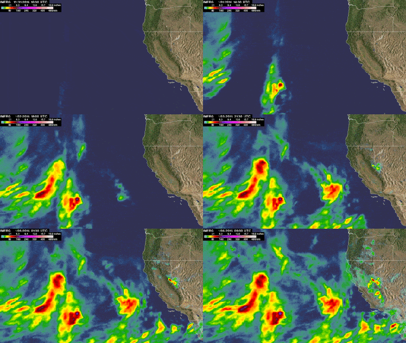
The visualization shows rain accumulation over the United States from Dec. 1, 2015, to Feb. 15, 2016, with blue and green areas indicating light precipitation and red patches indicating areas with high-accumulated rainfall. The rain accumulation map resets to zero at the beginning of each month. The data comes from NASA and the Japan Aerospace Exploration Agency’s Global Precipitation Measurement mission (GPM), a constellation of international and domestic satellites that estimate rainfall and snowfall every three hours.
At the beginning of December, the Pacific Northwest and Southeastern United States accumulated a lot of rainfall while the Midwest experienced a significant amount in the middle of the month. Over Christmas and New Year’s Day, heavy precipitation fell over the U.S. Southeast, particularly in Georgia, Tennessee, Virginia, North Carolina and Alabama, which experienced flash flooding.
Download the high-resolution version from the Scientific Visualization Studio
In January, patches of California and areas near the Gulf of Mexico, especially towards the end of the month, experienced high levels of rainfall. In early and mid-February, large, heavy patches of rain quickly developed over the Southeast region. This visualization also shows that some areas of the country, like southern California, did not receive rain consistently through the winter months.
“It’s not necessarily correct that it’s going to be wet in California the whole time. The precipitation shifts depend on what time and where you happen to be,” said Huffman.
According to Huffman, it’s difficult to know what precipitation is associated with El Niño and what isn’t in places outside the tropical Pacific. For instance, winds from the eastern tropics can travel and bring moisture to relatively nearby areas, such as California, he said. To see if areas farther away are associated with El Niño, scientists refer to historical weather patterns and to look at trends of where precipitation normally occurs during El Niño events. Also, several factors—not just El Nino—can contribute to unusual weather pattern.
According to the National Oceanic and Atmospheric Administration, El Niño was expected to produce wetter-than-average conditions from December 2015 to February 2016 in the southern area of the United States, including central California, across Texas, to Florida, and up the East Coast to southern New England— similar to the winter observations made so far by NASA satellites.
“Observing rainfall in an El Niño year is especially interesting because the prevailing precipitation patterns change, often in extreme ways. Some areas become wetter. Some areas become drier,” said Dalia Kirschbaum, a research scientist who studies precipitation and landslides at Goddard. “By seeing the whole globe, we are able to better understand how the precipitation is impacting different areas.”
Kirschbaum said the Pacific Northwest has experienced a higher than normal number of landslides due to increased precipitation. In late December to early January, southern California also experienced particularly extreme rain events that induced flash floods and mudslides. El Niño did not strictly cause this storm system but likely exacerbated the conditions, said Kirschbaum. GPM captured this particular storm system developing over the Pacific and making landfall in California.
Satellite observations from GPM, like its satellite predecessor the Tropical Rainfall Measuring Mission, are vital because they can measure rain accumulation over oceans, where the majority of rainfall occurs. During an El Niño, satellites often observe a shift in precipitation over the ocean, specifically an increase in rain over the eastern Pacific, said Huffman.
Based on past El Niño events, rainfall associated with the global phenomenon should continue through June, said Huffman. The impacts of El Niño take a while to propagate around the globe, and people may continue to see effects of El Niño associated with shifted rain patterns such as droughts, floods and fires.
As El Niño wanes, a La Niña event may follow as occurred after the strong 1997-1998 El Niño. La Niña is a similarly periodical natural occurring event related to ocean temperatures in the Pacific Ocean. Instead of warm water collecting off the coast of South America like in El Niño, La Niña is characterized by colder surface water near South America. La Niña can also spur abnormal weather patterns across the world.
“A La Nina occurring is a possibility,” said Huffman. “We’re prepared to observe and study the potential effects of La Niña with our satellites just as we are currently doing so with El Niño.”
For previous features on how NASA studies the 2015 El Niño:
NASA Studying 2015 El Nino Event As Never Before
NASA Examines Global Impacts of the 2015 El Nino
How NASA Sees El Nino Effects from Space
For NASA’s El Nino/La Nina Watch page, visit:

